
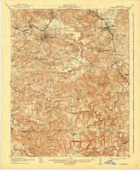
1913 Map of Drakesboro
USGS Topo · Published 1913About this map
Greenville serves as a primary hub for this 1913 survey of Muhlenberg and Todd counties, where the intersection of the Illinois Central RR and the Louisville and Nashville RR drives the local economy. The landscape is dotted with small-scale coal operations like Diamond Block and Diamond Springs, which supported communities such as Powderly, Bevier, and Drakesboro. This era is characterized by a dense network of country schools and general stores serving a rural population before modern road consolidation, with many families centered around landmarks like Dixon's Store and Mays Store.
Find a feature on this map
88 named features on this map. Tap any name to fly to it.
Don’t see what you’re looking for? This feature index may not catch every label — zoom into the map to look around manually.
Map Details
Editions of this 1913 Drakesboro Map
2 editions found
Other maps of this area

1909 · Madisonville
USGS Topo · 1:62,500

1909 · Hartford
USGS Topo · 1:62,500

1909 · Central City
USGS Topo · 1:62,500

1911 · Drakesboro
USGS Topo · 1:48,000

1911 · Dunmor
USGS Topo · 1:48,000

1912 · Nortonville
USGS Topo · 1:62,500

1914 · Dunmor
USGS Topo · 1:62,500

1951 · Lewisburg
USGS Topo · 1:24,000

1952 · Sharon Grove
USGS Topo · 1:24,000

1952 · Allegre
USGS Topo · 1:24,000