1990s Maps of Muhlenberg County, Kentucky
Explore 4 historic maps of Muhlenberg County from the 1990s. These maps offer a rare glimpse into what life looked like during the 1990s — showing old roads, neighborhoods, homes, and landmarks that have changed or disappeared over time.
Whether you're researching your family's past, planning a metal detecting trip, or studying how Muhlenberg County's landscape evolved across the 1990s, these high-resolution maps are a powerful tool for exploring the history of this region.
- Focus on a specific era: All maps on this page are from the 1990s, giving you a focused view of this time period.
- See what’s changed: Compare century-old streets, trails, and buildings to today's modern landscape using overlays and satellite layers.
- Research with precision: Use these maps for genealogy, historical research, land use analysis, or educational projects.
- View, download, or print: Maps are fully viewable online in high resolution, and can be downloaded or printed for your own records.
Start exploring Muhlenberg County's history through authentic maps from the 1990s. This is your window into the past.
Muhlenberg County, KY maps
(4)- 1997 Map of Central City East, 1999 Print
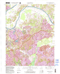 1997 Central City East1999 Print · USGSMuhlenberg County's coal country and the Green River valley are shown in the 1990s as industry reshapes the terrain. Genealogists can locate family landmarks like Rose Hill Cem and Green River Chapel or trace the early layouts of Cleaton and Martwick.
 - 1997 Map of Greenville, 2001 Print
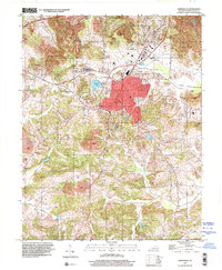 1997 Greenville2001 Print · USGSMuhlenberg County in the late nineties showcases a landscape shaped by coal mining and established rural communities. Local historians can trace the footprint of mining operations alongside landmarks like Old Liberty Cem, Luzerne Lake, and the Agricultural Experimental Station.
 - 1997 Map of Drakesboro, 2001 Print
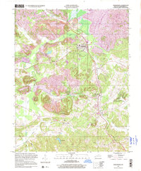 1997 Drakesboro2001 Print · USGSMuhlenberg County's coal-mining landscape is preserved here as it appeared in the late twentieth century, centered on the hub of Drakesboro. Genealogists and historians can trace industrial sites like the Tipple alongside local landmarks such as Ennis Cem and Hazel Creek Ch.
 - 1997 Map of Central City West, 2001 Print
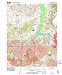 1997 Central City West2001 Print · USGSMuhlenberg County in the late nineties showcases a complex balance of heavy coal production and extensive wildlife conservation. Genealogists can locate family landmarks like Bethlehem Cem and Shavers Chapel while tracing the reach of regional Strip Mines.
End of results
Showing maps 1-4 of 4
Top cities of Muhlenberg County
- Central City historical maps
- Greenville historical maps
- Powderly historical maps
- Drakesboro historical maps
- Bremen historical maps
- South Carrollton historical maps
Frequently asked questions
- What are the different types of historical maps available for Muhlenberg County?
- What is the oldest map of Muhlenberg County?
- Where can I purchase historical maps of Muhlenberg County for my home or office?
- Where can I download high-res historical maps of Muhlenberg County?
- Are there historical topographic maps available for Muhlenberg County?
- Is there historical aerial imagery available for Muhlenberg County?
- Where are historical maps of Muhlenberg County sourced from?