1960s Maps of Perry County, Kentucky
Explore 9 historic maps of Perry County from the 1960s. These maps offer a rare glimpse into what life looked like during the 1960s — showing old roads, neighborhoods, homes, and landmarks that have changed or disappeared over time.
Whether you're researching your family's past, planning a metal detecting trip, or studying how Perry County's landscape evolved across the 1960s, these high-resolution maps are a powerful tool for exploring the history of this region.
- Focus on a specific era: All maps on this page are from the 1960s, giving you a focused view of this time period.
- See what’s changed: Compare century-old streets, trails, and buildings to today's modern landscape using overlays and satellite layers.
- Research with precision: Use these maps for genealogy, historical research, land use analysis, or educational projects.
- View, download, or print: Maps are fully viewable online in high resolution, and can be downloaded or printed for your own records.
Start exploring Perry County's history through authentic maps from the 1960s. This is your window into the past.
Perry County, KY maps
(9)- 1960 Map of Jenkins
 1960 Jenkins1960 Print · USGSEastern Kentucky and the West Virginia borderlands are captured at a mid-century peak of the coal and rail era. Trace the industrial corridors of the Chesapeake and Ohio RR through mountain hubs like Hazard and Jenkins.
 - 1960 Map of Johnson City
 1960 Johnson City1960 Print · USGSUpper East Tennessee and the surrounding tri-state area are shown in the mid-fifties during the height of the TVA reservoir era. Trace the industrial rail lines of the Southern and Louisville and Nashville between Kingsport and Johnson City.
 - 1961 Map of Hyden West, 1962 Print
 1961 Hyden West1962 Print · USGSLeslie County during the early 1960s shows a landscape of deep hollows and river bends before modern highway expansion. You can trace family locations near Thousandsticks, find the local Drive-in Theater, or locate rural landmarks like Grace Chapel.2 unique versions available
 - 1961 Map of Krypton, 1962 Print
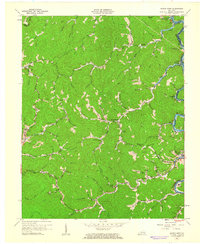
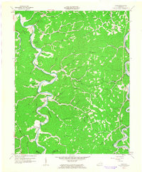
 1961 Krypton1962 Print · USGSPerry County and the surrounding coalfields appear here in the early sixties, as the river-and-rail economy defined life along the mountain forks. Local historians can trace family roots at Red Hill Cem or locate vanished schoolhouses like Pigeonroost Sch and Butterfly Sch.
 - 1961 Map of Haddix, 1962 Print
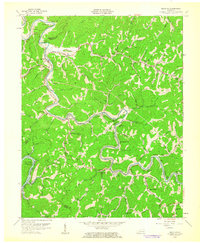
 1961 Haddix1962 Print · USGSBreathitt County in the early sixties was a landscape of coal mines and riverside rail depots connected by the winding Troublesome Creek. Genealogists and historians can trace family ties through Haddix Cem, locate the Riverside Christian Training Sch, and find old post offices like Copland (Saldee PO).
 - 1961 Map of Buckhorn, 1963 Print
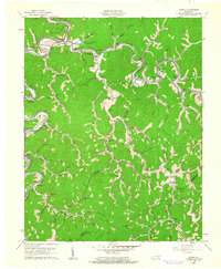
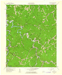
 1961 Buckhorn1963 Print · USGSThe hills of Perry and Leslie counties are captured here just after the completion of the Buckhorn Dam and the filling of the reservoir. Genealogists can trace early mountain life through numerous rural schools like Strong Branch Sch and settlements at Bowlingtown and Saul.2 unique versions available
 - 1961 Map of Canoe, 1963 Print
 1961 Canoe1963 Print · USGSBreathitt County's serpentine river valleys and ridge-top lookouts are frozen in time here during the early sixties. Researchers can trace family homesteads and local landmarks like Beech PO, Shoulderblade Creek, and the Herald Cem.2 unique versions available
 - 1961 Map of Hyden East, 1963 Print
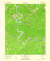
 1961 Hyden East1963 Print · USGSLeslie County during the early 1960s shows a landscape of river-valley settlements and rural schoolhouses. Researchers can locate family landmarks like the Hendrix Cem and Town Chapel, or trace the development of Buckhorn Reservoir and Wooton.
 - 1963 Map of Johnson City
 1963 Johnson City1963 Print · USGSThe Tri-Cities and the surrounding Appalachian ridges are shown in detail during the early sixties, highlighting the era's vital rail and river networks. Genealogists and historians can trace the routes of the Clinchfield RR and locate settlements from Rogersville to Elizabethton.
End of results
Showing maps 1-9 of 9
Top cities of Perry County
Frequently asked questions
- What are the different types of historical maps available for Perry County?
- What is the oldest map of Perry County?
- Where can I purchase historical maps of Perry County for my home or office?
- Where can I download high-res historical maps of Perry County?
- Are there historical topographic maps available for Perry County?
- Is there historical aerial imagery available for Perry County?
- Where are historical maps of Perry County sourced from?