1990s Maps of Perry County, Kentucky
Explore 5 historic maps of Perry County from the 1990s. These maps offer a rare glimpse into what life looked like during the 1990s — showing old roads, neighborhoods, homes, and landmarks that have changed or disappeared over time.
Whether you're researching your family's past, planning a metal detecting trip, or studying how Perry County's landscape evolved across the 1990s, these high-resolution maps are a powerful tool for exploring the history of this region.
- Focus on a specific era: All maps on this page are from the 1990s, giving you a focused view of this time period.
- See what’s changed: Compare century-old streets, trails, and buildings to today's modern landscape using overlays and satellite layers.
- Research with precision: Use these maps for genealogy, historical research, land use analysis, or educational projects.
- View, download, or print: Maps are fully viewable online in high resolution, and can be downloaded or printed for your own records.
Start exploring Perry County's history through authentic maps from the 1990s. This is your window into the past.
Perry County, KY maps
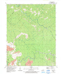
(5)- 1992 Map of Hazard North
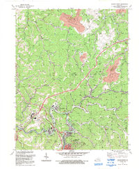 1992 Hazard North1992 Print · USGSIn the early 1990s, the hollows and ridge lines north of HAZARD remained defined by the coal industry and mountain settlements. Researchers can trace families and operations through landmarks like Blue Diamond, the L & N RR corridor, and Hunter Memorial Ch.
 - 1992 Map of Hazard South
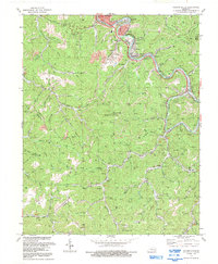 1992 Hazard South1992 Print · USGSPerry County's coal and rail heritage is on full display in the early nineties as industry follows the North Fork Kentucky River. Researchers can trace genealogical roots at Caudill Cem or locate former mining hubs like Glomawr, Lothair, and Diablock.
 - 1992 Map of Carrie
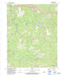 1992 Carrie1992 Print · USGSKnott County's coal country comes into focus in this early 1990s survey, showing the deep hollows and high ridges surrounding Troublesome Creek. Researchers can locate several remote communities and landmarks like Lotts Creek Community Sch, Hardburly, and Fisty.
 - 1992 Map of Vicco
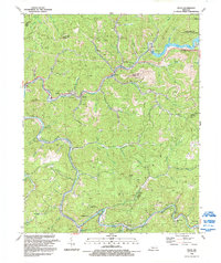 1992 Vicco1992 Print · USGSThe coal country of Perry and Knott Counties comes alive in the 1990s, showing a landscape of ridge-top mines and valley settlements. Genealogists can trace family sites around Vicco, Cornettsville, and Happy, or find historic congregations like Indian Bottom Ch.
 - 1992 Map of Vest
 1992 Vest1992 Print · USGSKnott County's narrow hollows and deep creek beds are captured here in the early nineties, revealing a landscape shaped by both tradition and industry. Genealogists can trace family landmarks and burial sites like Compton Cem, Dobson Cem, and the community at Vest.
End of results
Showing maps 1-5 of 5
Top cities of Perry County
Frequently asked questions
- What are the different types of historical maps available for Perry County?
- What is the oldest map of Perry County?
- Where can I purchase historical maps of Perry County for my home or office?
- Where can I download high-res historical maps of Perry County?
- Are there historical topographic maps available for Perry County?
- Is there historical aerial imagery available for Perry County?
- Where are historical maps of Perry County sourced from?