1910s Maps of Beaver Bottom, Cedarville
Explore 3 historic maps of Beaver Bottom from the 1910s. These maps offer a rare glimpse into what life looked like during the 1910s — showing old roads, neighborhoods, homes, and landmarks that have changed or disappeared over time.
Whether you're researching your family's past, planning a metal detecting trip, or studying how Beaver Bottom's landscape evolved across the 1910s, these high-resolution maps are a powerful tool for exploring the history of this region.
- Focus on a specific era: All maps on this page are from the 1910s, giving you a focused view of this time period.
- See what’s changed: Compare century-old streets, trails, and buildings to today's modern landscape using overlays and satellite layers.
- Research with precision: Use these maps for genealogy, historical research, land use analysis, or educational projects.
- View, download, or print: Maps are fully viewable online in high resolution, and can be downloaded or printed for your own records.
Start exploring Beaver Bottom's history through authentic maps from the 1910s. This is your window into the past.
Beaver Bottom, Cedarville maps
(3)- 1915 Map of Regina
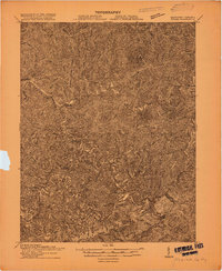 1915 Regina1915 Print · USGSPike County at the dawn of the coal boom is defined by a dense river-and-rail network along the Levisa Fork. Genealogists and historians can trace old post offices and rail stops like Shelbiana P.O., Mouthcard, and Elkhorn City.2 unique versions available
 - 1916 Map of Regina
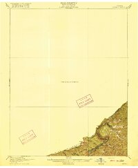 1916 Regina1916 Print · USGSThe Virginia and Kentucky borderlands are captured here in the years before the Great War, focusing on the dramatic river gorge country. Genealogists and hikers can trace the Carolina Clinchfield and Ohio rail route near The Breaks and The Towers.2 unique versions available
 - 1917 Map of Regina
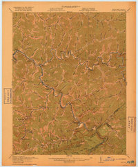 1917 Regina1917 Print · USGSThe Pike County coalfields and the winding Kentucky-Virginia border are captured here just before the close of the Great War. Genealogists can locate family homes and old post offices at Sutton PO, Regina PO, and Carmen PO along the steep hollows.3 unique versions available
End of results
Showing maps 1-3 of 3
Frequently asked questions
- What are the different types of historical maps available for Beaver Bottom?
- What is the oldest map of Beaver Bottom?
- Where can I purchase historical maps of Beaver Bottom for my home or office?
- Where can I download high-res historical maps of Beaver Bottom?
- Are there historical topographic maps available for Beaver Bottom?
- Is there historical aerial imagery available for Beaver Bottom?
- Where are historical maps of Beaver Bottom sourced from?