1970s Maps of Rowan County, Kentucky
Explore 9 historic maps of Rowan County from the 1970s. These maps offer a rare glimpse into what life looked like during the 1970s — showing old roads, neighborhoods, homes, and landmarks that have changed or disappeared over time.
Whether you're researching your family's past, planning a metal detecting trip, or studying how Rowan County's landscape evolved across the 1970s, these high-resolution maps are a powerful tool for exploring the history of this region.
- Focus on a specific era: All maps on this page are from the 1970s, giving you a focused view of this time period.
- See what’s changed: Compare century-old streets, trails, and buildings to today's modern landscape using overlays and satellite layers.
- Research with precision: Use these maps for genealogy, historical research, land use analysis, or educational projects.
- View, download, or print: Maps are fully viewable online in high resolution, and can be downloaded or printed for your own records.
Start exploring Rowan County's history through authentic maps from the 1970s. This is your window into the past.
Rowan County, KY maps
(9)- 1970 Map of Morehead, 1972 Print
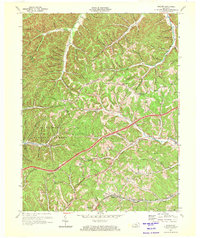
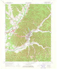 1970 Morehead1972 Print · USGSMorehead and the surrounding Rowan County hills are captured here in the early 1970s, as the university and railroad shaped the local landscape. Researchers can trace the development of Morehead State University or locate family sites like Caddill Cem and Dry Creek Ch.2 unique versions available
 - 1970 Map of Farmers, 1972 Print
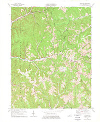
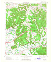 1970 Farmers1972 Print · USGSRowan and Bath counties in the early seventies reveal a landscape of river-bend settlements and deep forest ridges. Genealogists and locals can trace family sites like Eldridge Cem, find the old crossing at Moores Ferry, and follow the Chesapeake and Ohio rail line.2 unique versions available
 - 1970 Map of Colfax, 1972 Print
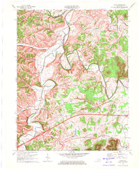 1970 Colfax1972 Print · USGSBath and Fleming Counties appear here in the early seventies, as rural life moved along the high ridges and deep hollows of the Licking River. Genealogists and historians can trace local family lineages through remote sites like Old Virginia Cem, Grange City, and Atchison Cem.2 unique versions available
 - 1970 Map of Cranston, 1972 Print
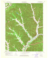 1970 Cranston1972 Print · USGSThe Daniel Boone National Forest in the 1970s reveals a landscape of isolated hollows and ridge-top lookouts. Genealogists can locate family landmarks like Evans Cem and rural centers such as Cranston, Smile, and the Hickory Flats Lookout Tower.
 - 1970 Map of Soldier, 1972 Print
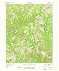
 1970 Soldier1972 Print · USGSThe foothills of eastern Kentucky come into focus here in the early seventies, detailing the rail and river corridor between Carter and Lewis counties. Researchers can trace the Chesapeake and Ohio tracks through Soldier and Haldeman or locate Bowen Chapel and Patton Cem.
 - 1975 Map of Salt Lick, 1977 Print
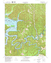
 1975 Salt Lick1977 Print · USGSBath and Rowan counties in the mid-seventies reveal a landscape reshaped by the waters of Cave Run Lake and the Licking River. Genealogists and historians can trace the C & O rail corridor and find local sites like Clear Creek Furnace and Upper Salt Lick Ch.
 - 1977 Map of Haldeman
 1977 Haldeman1977 Print · USGSThe ridges of Rowan and Carter County are shown in the late seventies as the timber and mining landscape matured. Genealogists can trace family names through landmarks like Christian Cem, Slabcamp Ch, and the rail stops at Hays Crossing.
 - 1977 Map of Wrigley
 1977 Wrigley1977 Print · USGSThe Licking River valley in Morgan and Elliott counties is captured here in the late seventies. Family historians and researchers can locate Blairs Mills, the Jones Cem, and rural congregations at Oak Hill Ch.2 unique versions available
 - 1979 Map of Bangor
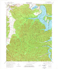
 1979 Bangor1979 Print · USGSThe Licking River valley was being transformed into a major reservoir in the late 1970s, reshaping the local landscape. Genealogists and historians can trace the rising waters of Cave Run Lake around Bangor, the Poppin Rock Tunnel, and the Claypits.2 unique versions available
End of results
Showing maps 1-9 of 9
Top cities of Rowan County
Frequently asked questions
- What are the different types of historical maps available for Rowan County?
- What is the oldest map of Rowan County?
- Where can I purchase historical maps of Rowan County for my home or office?
- Where can I download high-res historical maps of Rowan County?
- Are there historical topographic maps available for Rowan County?
- Is there historical aerial imagery available for Rowan County?
- Where are historical maps of Rowan County sourced from?