1970s Maps of Russell County, Kentucky
Explore 10 historic maps of Russell County from the 1970s. These maps offer a rare glimpse into what life looked like during the 1970s — showing old roads, neighborhoods, homes, and landmarks that have changed or disappeared over time.
Whether you're researching your family's past, planning a metal detecting trip, or studying how Russell County's landscape evolved across the 1970s, these high-resolution maps are a powerful tool for exploring the history of this region.
- Focus on a specific era: All maps on this page are from the 1970s, giving you a focused view of this time period.
- See what’s changed: Compare century-old streets, trails, and buildings to today's modern landscape using overlays and satellite layers.
- Research with precision: Use these maps for genealogy, historical research, land use analysis, or educational projects.
- View, download, or print: Maps are fully viewable online in high resolution, and can be downloaded or printed for your own records.
Start exploring Russell County's history through authentic maps from the 1970s. This is your window into the past.
Russell County, KY maps
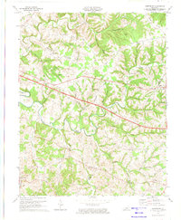
(10)- 1970 Map of Dunnville, 1972 Print
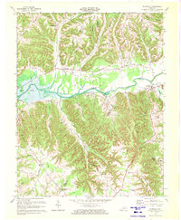 1970 Dunnville1972 Print · USGSAdair and Casey counties appear during the early 1970s as the Green River Lake reservoir reshapes the valley. Researchers can find numerous family burial grounds and country churches like Williams Cem, Shady Grove Ch, and the Mt Calvary Cem Ch.
 - 1973 Map of Eli, 1974 Print
 1973 Eli1974 Print · USGSRussell and Pulaski counties are shown here in the early seventies as the region balanced its agrarian roots with modern infrastructure. Genealogists and historians can trace family locations near Irvins Store, Old Friendship Cem, and Locust Grove Ch.
 - 1973 Map of Faubush, 1974 Print
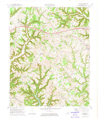 1973 Faubush1974 Print · USGSPulaski County’s rolling ridge country is documented here in the early 1970s as the Cumberland Parkway bisects the rural landscape. Researchers can trace family roots at Cedar Point Cemetery, Mt Zion Ch, and the settlement of Faubush.2 unique versions available
 - 1973 Map of Russell Springs, 1974 Print
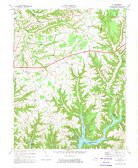
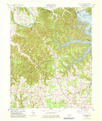
 1973 Russell Springs1974 Print · USGSRussell County and the Adair County line are captured here in the early seventies as the region balanced its rural roots with new infrastructure. Genealogists can trace family landmarks like Mt Hope Ch, Hillcrest Cem, and the old settlements of Sano and Humble.
 - 1973 Map of Montpelier, 1974 Print
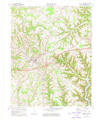
 1973 Montpelier1974 Print · USGSAdair and Russell Counties are shown here during the early seventies as the modern highway system began to intersect with old ridge-top settlements. Researchers can locate numerous rural landmarks like Gentrys Mill, New Concord Ch, and Wildcat Cave Hol.2 unique versions available
 - 1978 Map of Wolf Creek Dam
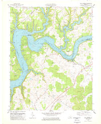
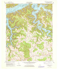
 1978 Wolf Creek Dam1978 Print · USGSThe Lake Cumberland shoreline and the Cumberland River valley are captured in the late seventies as the region balanced local industry and recreation. Trace family roots and old landmarks from Winfreys Ferry to the community of Seventy Six and the Seventy Six Falls.3 unique versions available
 - 1978 Map of Mill Springs
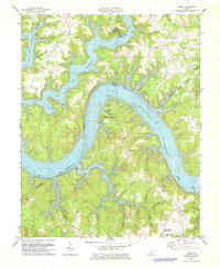
 1978 Mill Springs1978 Print · USGSLake Cumberland was already a well-established recreational destination by the late seventies, reshaped by the impoundment of the river. Genealogists can trace family names and historic sites like Steubenville, Morrow Chapel, and the Mill Springs Battlefield.
 - 1978 Map of Jabez
 1978 Jabez1978 Print · USGSNear the border of Russell and Wayne counties in the late 1970s, the landscape was defined by the winding waters of Lake Cumberland. Researchers can trace rural lineages through family landmarks like Coffey Cem and the small settlements of Ono and Eadsville.
 - 1978 Map of Cumberland City
 1978 Cumberland City1978 Print · USGSClinton and Wayne Counties appear here in the late seventies, centered on the complex, winding shoreline of Lake Cumberland. Genealogists and local historians can locate many family sites, from the Hickory Ridge Cem to the rural community of Alpha.2 unique versions available
 - 1978 Map of Jamestown, 1979 Print
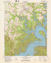 1978 Jamestown1979 Print · USGSLake Cumberland is shown in the late seventies as a mature recreational hub, with its winding shoreline defining the local topography. Trace family-owned landmarks and rural life near Sewellton and Freedom, or locate old sites like Lawless Cem and Concord Ch.
End of results
Showing maps 1-10 of 10
Top cities of Russell County
Frequently asked questions
- What are the different types of historical maps available for Russell County?
- What is the oldest map of Russell County?
- Where can I purchase historical maps of Russell County for my home or office?
- Where can I download high-res historical maps of Russell County?
- Are there historical topographic maps available for Russell County?
- Is there historical aerial imagery available for Russell County?
- Where are historical maps of Russell County sourced from?