1980s Maps of Spencer County, Kentucky
Explore 5 historic maps of Spencer County from the 1980s. These maps offer a rare glimpse into what life looked like during the 1980s — showing old roads, neighborhoods, homes, and landmarks that have changed or disappeared over time.
Whether you're researching your family's past, planning a metal detecting trip, or studying how Spencer County's landscape evolved across the 1980s, these high-resolution maps are a powerful tool for exploring the history of this region.
- Focus on a specific era: All maps on this page are from the 1980s, giving you a focused view of this time period.
- See what’s changed: Compare century-old streets, trails, and buildings to today's modern landscape using overlays and satellite layers.
- Research with precision: Use these maps for genealogy, historical research, land use analysis, or educational projects.
- View, download, or print: Maps are fully viewable online in high resolution, and can be downloaded or printed for your own records.
Start exploring Spencer County's history through authentic maps from the 1980s. This is your window into the past.
Spencer County, KY maps
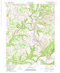
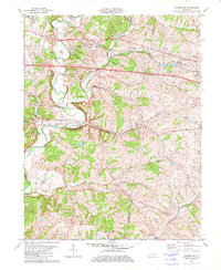
(5)- 1981 Map of Waterford
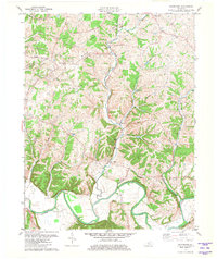 1981 Waterford1981 Print · USGSSpencer and Bullitt counties are captured here in the early 1980s, showcasing a landscape defined by the deep valleys of the Salt River. Local researchers can trace family landmarks and rural crossings near Waterford, Wilsonville, and Wheelers Ridge.3 unique versions available
 - 1981 Map of Elizabethtown, 1983 Print
 1981 Elizabethtown1983 Print · USGSCentral Kentucky in the early eighties shows a landscape of military installations, state parks, and historic sites. Genealogists and historians can trace rail lines like the Louisville and Nashville or locate sites like Lebanon National Cemetery and the Lincoln Memorial National Historic Site.
 - 1982 Map of Mount Washington
 1982 Mount Washington1982 Print · USGSMount Washington and the Bullitt County borderlands are shown here in the early eighties as rural life and suburban growth began to meet. Researchers can find numerous family cemeteries and country churches, from St Francis Cem to Oak Grove Ch.3 unique versions available
 - 1982 Map of Fisherville
 1982 Fisherville1982 Print · USGSEastern Jefferson County's rural landscape is captured here during the early eighties, showing the transition between farmsteads and suburban growth. Genealogists and locals can trace family lands near Fisherville, the Job Corps Center at Lincoln Ridge, and old rail stops like Boston.3 unique versions available
 - 1986 Map of Louisville
 1986 Louisville1986 Print · USGSMid-1980s Louisville and southern Indiana are shown here during a decade of significant suburban growth and infrastructure development. Researchers can trace the layout of Cave Hill Cemetery, the expansion of Standiford Field, and industrial sites like the Indiana Army Ammunition Plant.2 unique versions available
End of results
Showing maps 1-5 of 5
Top cities of Spencer County
Frequently asked questions
- What are the different types of historical maps available for Spencer County?
- What is the oldest map of Spencer County?
- Where can I purchase historical maps of Spencer County for my home or office?
- Where can I download high-res historical maps of Spencer County?
- Are there historical topographic maps available for Spencer County?
- Is there historical aerial imagery available for Spencer County?
- Where are historical maps of Spencer County sourced from?