1960s Maps of Memphis Junction, Kentucky
Explore 1 historic maps of Memphis Junction from the 1960s. These maps offer a rare glimpse into what life looked like during the 1960s — showing old roads, neighborhoods, homes, and landmarks that have changed or disappeared over time.
Whether you're researching your family's past, planning a metal detecting trip, or studying how Memphis Junction's landscape evolved across the 1960s, these high-resolution maps are a powerful tool for exploring the history of this region.
- Focus on a specific era: All maps on this page are from the 1960s, giving you a focused view of this time period.
- See what’s changed: Compare century-old streets, trails, and buildings to today's modern landscape using overlays and satellite layers.
- Research with precision: Use these maps for genealogy, historical research, land use analysis, or educational projects.
- View, download, or print: Maps are fully viewable online in high resolution, and can be downloaded or printed for your own records.
Start exploring Memphis Junction's history through authentic maps from the 1960s. This is your window into the past.
Memphis Junction, KY maps
(1)- 1968 Map of Bowling Green South, 1970 Print
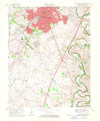 1968 Bowling Green South1970 Print · USGSBowling Green was expanding rapidly in the late 1960s, as new suburbs reached toward the Tennessee border. Genealogists and historians can trace family plots and rural congregations at Mount Moriah Cem, Potter Grave, and Little Zion Ch.2 unique versions available
End of results
Showing maps 1-1 of 1
Top cities near Memphis Junction
- Bowling Green historical maps
- Franklin historical maps
- Scottsville historical maps
- Auburn historical maps
- Plum Springs historical maps
- Woodburn historical maps
See more
Frequently asked questions
- What are the different types of historical maps available for Memphis Junction?
- What is the oldest map of Memphis Junction?
- Where can I purchase historical maps of Memphis Junction for my home or office?
- Where can I download high-res historical maps of Memphis Junction?
- Are there historical topographic maps available for Memphis Junction?
- Is there historical aerial imagery available for Memphis Junction?
- Where are historical maps of Memphis Junction sourced from?