1940s Maps of Acadia Parish, Louisiana
Explore 17 historic maps of Acadia Parish from the 1940s. These maps offer a rare glimpse into what life looked like during the 1940s — showing old roads, neighborhoods, homes, and landmarks that have changed or disappeared over time.
Whether you're researching your family's past, planning a metal detecting trip, or studying how Acadia Parish's landscape evolved across the 1940s, these high-resolution maps are a powerful tool for exploring the history of this region.
- Focus on a specific era: All maps on this page are from the 1940s, giving you a focused view of this time period.
- See what’s changed: Compare century-old streets, trails, and buildings to today's modern landscape using overlays and satellite layers.
- Research with precision: Use these maps for genealogy, historical research, land use analysis, or educational projects.
- View, download, or print: Maps are fully viewable online in high resolution, and can be downloaded or printed for your own records.
Start exploring Acadia Parish's history through authentic maps from the 1940s. This is your window into the past.
Acadia Parish, LA maps
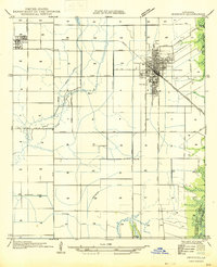
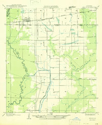
(17)- 1946 Map of Morse
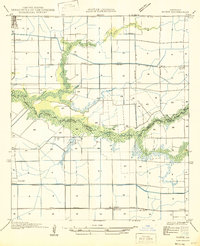 1946 Morse1946 Print · USGSCoastal Louisiana at the end of the Second World War reveals a landscape defined by its bayous and early irrigation networks. Genealogists and researchers can locate old rail stops like Haire Sta and settlements such as Morse, Gueydan, and Lyons Point.
 - 1946 Map of Lake Arthur
 1946 Lake Arthur1946 Print · USGSLake Arthur and its surrounding marshlands are shown here in the mid-forties during a period of steady coastal development. Researchers can trace family sites near St Theresa Ch, locate the Andress Gate Cem, or follow the path of the Southern Pacific railroad.
 - 1946 Map of Mermentau
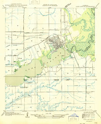
 1946 Mermentau1946 Print · USGSAcadia Parish in the mid-1940s centers on the critical rail and water junction at the Mermentau river crossing. Genealogists and local historians can trace family locations near Quibodeau Cem, the Sand Mill, and the rail stops at Midland or Egan.
 - 1946 Map of Kaplan
 1946 Kaplan1946 Print · USGSVermilion and Acadia Parishes come to life in the mid-1940s as the rice-farming landscape of southwest Louisiana expands. Trace the early streets of Kaplan, the Southern Pacific rail line, and rural landmarks like the Apshire Cem and Leleux.
 - 1946 Map of Rayne
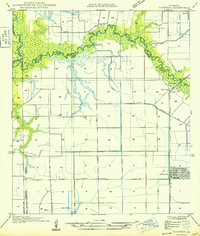
 1946 Rayne1946 Print · USGSAcadia Parish at the close of the Second World War shows a landscape shaped by rail lines and irrigation canals. Genealogists and local researchers can locate old community centers like Ebenezer Sch and Hebron Ch, or trace the winding parish boundaries along Bayou Queue De Tortue.
 - 1946 Map of Jennings
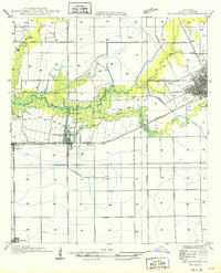
 1946 Jennings1946 Print · USGSJefferson Davis Parish is documented here shortly after the war, showing the well-defined street layouts of Jennings and Roanoke. Genealogists and historians can trace property lines alongside the Southern Pacific railroad or follow the essential drainage of Sturdivant Canal.
 - 1947 Map of Evangeline
 1947 Evangeline1947 Print · USGSAcadia Parish and the Jefferson Davis Parish border are captured mid-century during a period of massive agricultural irrigation development. Genealogists and historians can trace family locations near Evangeline, St Josephs Ch, and the Riverside Cem.
 - 1947 Map of Branch
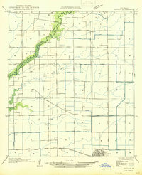
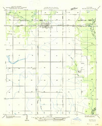
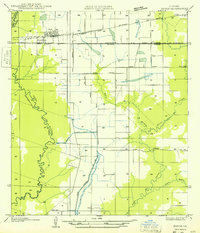
 1947 Branch1947 Print · USGSAcadia Parish in the mid-1940s is shown here as a landscape of winding bayous and rural rail stops. Researchers can trace family sites like Lower Roberts Cove and locate community landmarks including Black Sch and Maryland Chapel.
 - 1947 Map of Elton
 1947 Elton1947 Print · USGSJefferson Davis Parish was a landscape of rail-dependent farming communities in the late 1940s. Genealogists and local historians can locate rural landmarks such as China Cem, Fusilier Sch, and the small settlement of Wilburton.
 - 1947 Map of Eunice
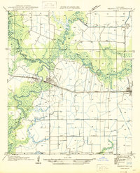
 1947 Eunice1947 Print · USGSThe rail-and-bayou landscape of south Louisiana comes alive in the mid-1940s, centered on the growing town of Eunice. Local researchers can trace family roots through rural landmarks like Bozyone Sch and the smaller settlements of Mowata and Amy.
 - 1947 Map of Hathaway
 1947 Hathaway1947 Print · USGSJefferson Davis Parish in the late 1940s reveals a specialized landscape of rice farming and rural crossroads. Genealogists and researchers can trace old school sites like Grand Marais Sch and the community layouts of Hathaway and Raymond.
 - 1947 Map of Iota
 1947 Iota1947 Print · USGSAcadia Parish at the height of its mid-century agricultural development reveals a landscape defined by rice irrigation and rail transport. Genealogists and local historians can trace family locations near McCain Cem, the village of Iota, and the stops along the Southern Pacific railroad.
 - 1947 Map of Pitreville
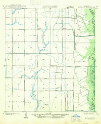
 1947 Pitreville1947 Print · USGSLouisiana's Acadia and St. Landry parishes are captured here in the mid-1940s, showing a rural landscape shaped by winding bayous and early highways. Genealogists and local historians can locate family landmarks like Courville Cem, Hundley Sch, and the Acadia Academy.
 - 1947 Map of Basile
 1947 Basile1947 Print · USGSBasile and the surrounding Louisiana prairie are captured here in the late 1940s as the region's agricultural and rail networks were fully established. Researchers can trace family sites near Reed Cem and St Monica Ch, or follow the industrial waterworks of the Mamou Canal.
 - 1949 Map of Gueydan
 1949 Gueydan1949 Print · USGSThe coastal prairies of Vermilion Parish meet the bayous of Acadia in the late 1940s. Genealogists can locate the Legia Cem and trace the Southern Pacific rail line through Riceville and into the streets of Gueydan.
 - 1949 Map of Estherwood
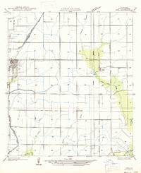
 1949 Estherwood1949 Print · USGSAcadia Parish in the late 1940s reveals a landscape defined by industrial rice farming and rail-line commerce. Genealogists and historians can trace the growth of Crowley, the Tartue Siding, and the irrigation network of Estherwood Canal.
 - 1949 Map of Basile
 1949 Basile1949 Print · USGSLouisiana's prairie and bayou country meet in the late 1940s at the junction of four different parishes. Researchers can trace the family landmarks of this agricultural landscape, from the Reed Cem and St Monica Ch to the remote Kaplan Pump Sta.
End of results
Showing maps 1-17 of 17
Top cities of Acadia Parish
- Crowley historical maps
- Rayne historical maps
- Church Point historical maps
- Iota historical maps
- Estherwood historical maps
- Mermentau historical maps
See more
Frequently asked questions
- What are the different types of historical maps available for Acadia Parish?
- What is the oldest map of Acadia Parish?
- Where can I purchase historical maps of Acadia Parish for my home or office?
- Where can I download high-res historical maps of Acadia Parish?
- Are there historical topographic maps available for Acadia Parish?
- Is there historical aerial imagery available for Acadia Parish?
- Where are historical maps of Acadia Parish sourced from?