1970s Maps of Peach Bloom, Louisiana
Explore 1 historic maps of Peach Bloom from the 1970s. These maps offer a rare glimpse into what life looked like during the 1970s — showing old roads, neighborhoods, homes, and landmarks that have changed or disappeared over time.
Whether you're researching your family's past, planning a metal detecting trip, or studying how Peach Bloom's landscape evolved across the 1970s, these high-resolution maps are a powerful tool for exploring the history of this region.
- Focus on a specific era: All maps on this page are from the 1970s, giving you a focused view of this time period.
- See what’s changed: Compare century-old streets, trails, and buildings to today's modern landscape using overlays and satellite layers.
- Research with precision: Use these maps for genealogy, historical research, land use analysis, or educational projects.
- View, download, or print: Maps are fully viewable online in high resolution, and can be downloaded or printed for your own records.
Start exploring Peach Bloom's history through authentic maps from the 1970s. This is your window into the past.
Peach Bloom, LA maps
(1)- 1970 Map of Carencro, 1972 Print
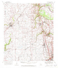 1970 Carencro1972 Print · USGSCajun country at the start of the seventies reveals a landscape where deep-rooted parish settlements like Grand Coteau exist alongside a booming energy industry. Trace family roots and local landmarks from Mt Pleasant Ch Cem to the Vatican Oil Field.
End of results
Showing maps 1-1 of 1
Top cities near Peach Bloom
- Lafayette historical maps
- Opelousas historical maps
- Crowley historical maps
- Eunice historical maps
- Rayne historical maps
- Scott historical maps
See more
Frequently asked questions
- What are the different types of historical maps available for Peach Bloom?
- What is the oldest map of Peach Bloom?
- Where can I purchase historical maps of Peach Bloom for my home or office?
- Where can I download high-res historical maps of Peach Bloom?
- Are there historical topographic maps available for Peach Bloom?
- Is there historical aerial imagery available for Peach Bloom?
- Where are historical maps of Peach Bloom sourced from?