1900s (20th Century) Maps of Le Jeune, Oberlin
Explore 8 historic maps of Le Jeune from the 1900s (20th Century). These maps offer a rare glimpse into what life looked like during the 1900s — showing old roads, neighborhoods, homes, and landmarks that have changed or disappeared over time.
Whether you're researching your family's past, planning a metal detecting trip, or studying how Le Jeune's landscape evolved across the 1900s, these high-resolution maps are a powerful tool for exploring the history of this region.
- Focus on a specific era: All maps on this page are from the 1900s, giving you a focused view of this time period.
- See what’s changed: Compare century-old streets, trails, and buildings to today's modern landscape using overlays and satellite layers.
- Research with precision: Use these maps for genealogy, historical research, land use analysis, or educational projects.
- View, download, or print: Maps are fully viewable online in high resolution, and can be downloaded or printed for your own records.
Start exploring Le Jeune's history through authentic maps from the 1900s. This is your window into the past.
Le Jeune, Oberlin maps
(8)- 1947 Map of Oberlin
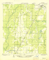 1947 Oberlin1947 Print · USGSOberlin and the surrounding Allen Parish countryside are shown here in the late 1930s and 40s during a period of transition for the local timber industry. Researchers can trace rural family sites near Bethany Ch or follow the path of the Missouri Pacific Railroad through Moeling and Lyles.
 - 1952 Map of Lake Charles
 1952 Lake Charles1952 Print · USGSSouthwest Louisiana is captured here in the mid-fifties, showing a landscape defined by the rise of the petrochemical industry and deep-water navigation. Researchers can trace family roots through numerous small-town settlements and oil developments like Nibletts Bluff, the Lockport Oil Field, and Starks.
 - 1954 Map of Oberlin
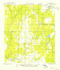 1954 Oberlin1954 Print · USGSAllen Parish at mid-century centers on the town of Oberlin and the vital corridor of the Missouri Pacific Railroad. Family historians can trace rural life through landmarks like Pilgrim Ch, St Johns Ch, and the small settlement at Moeling.
 - 1954 Map of Lake Charles, 1964 Print
 1954 Lake Charles1964 Print · USGSSouthwest Louisiana in the mid-fifties is defined by its massive petroleum industry and its complex network of bayous and rail lines. Researchers can trace the development of the Sulphur Mines Oil Field or locate historic settlements like Longville and De Quincy.3 unique versions available
 - 1961 Map of Oberlin, 1963 Print
 1961 Oberlin1963 Print · USGSAllen Parish during the early sixties shows a landscape of timber and oil development along the MISSOURI PACIFIC. Genealogists can trace family roots at Simmons Settlement and historic sites like Pine Chapel Cem or St Johns Ch.2 unique versions available
 - 1986 Map of Ville Platte
 1986 Ville Platte1986 Print · USGSCentral Louisiana in the 1980s reveals a complex landscape of pine forests and bayou networks spanning seven distinct parishes. Researchers can trace historic rail lines like the Atchison Topeka and Santa Fe RR and locate settlements such as Simmons Settlement, Redland, and Elizabeth.2 unique versions available
 - 1986 Map of Oberlin, 1987 Print
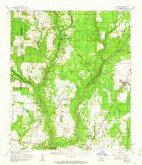
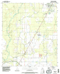
 1986 Oberlin1987 Print · USGSAllen Parish in the mid-1980s centered on the confluence of natural waterways and modern irrigation. Researchers can trace rural settlements like Le Jeune and Lyles, or locate the Coushatta Indian Reservation and the Lookout Tower.
 - 1994 Map of Oberlin, 1996 Print
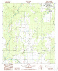
 1994 Oberlin1996 Print · USGSAllen Parish in the mid-nineties shows a rural landscape anchored by the Calcasieu River and the Coushatta Indian Res. Researchers can trace old railroad junctions at Elder and Le Jeune or locate family burial sites at various rural Cems.
End of results
Showing maps 1-8 of 8
Top cities near Le Jeune
- Oakdale historical maps
- Kinder historical maps
- Oberlin historical maps
- Basile historical maps
- Elton historical maps
Frequently asked questions
- What are the different types of historical maps available for Le Jeune?
- What is the oldest map of Le Jeune?
- Where can I purchase historical maps of Le Jeune for my home or office?
- Where can I download high-res historical maps of Le Jeune?
- Are there historical topographic maps available for Le Jeune?
- Is there historical aerial imagery available for Le Jeune?
- Where are historical maps of Le Jeune sourced from?