1990s Maps of Brignac, Louisiana
Explore 2 historic maps of Brignac from the 1990s. These maps offer a rare glimpse into what life looked like during the 1990s — showing old roads, neighborhoods, homes, and landmarks that have changed or disappeared over time.
Whether you're researching your family's past, planning a metal detecting trip, or studying how Brignac's landscape evolved across the 1990s, these high-resolution maps are a powerful tool for exploring the history of this region.
- Focus on a specific era: All maps on this page are from the 1990s, giving you a focused view of this time period.
- See what’s changed: Compare century-old streets, trails, and buildings to today's modern landscape using overlays and satellite layers.
- Research with precision: Use these maps for genealogy, historical research, land use analysis, or educational projects.
- View, download, or print: Maps are fully viewable online in high resolution, and can be downloaded or printed for your own records.
Start exploring Brignac's history through authentic maps from the 1990s. This is your window into the past.
Brignac, LA maps
(2)- 1991 Map of French Settlement
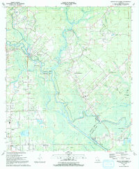 1991 French Settlement1991 Print · USGSThe Amite River basin of the early nineties shows a landscape of bayous and riverside villages. Genealogists can trace family names at Watson Cem and locate community anchors like St Joseph Ch and French Settlement.2 unique versions available
 - 1999 Map of French Settlement, 2000 Print
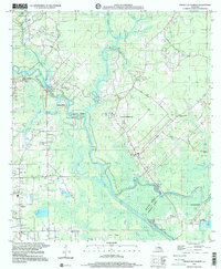 1999 French Settlement2000 Print · USGSLouisiana's river country at the turn of the millennium shows a landscape shaped by the Amite River and its intricate bayous. Researchers can trace local history through sites like French Settlement, Port Vincent, and many parish landmarks like Shiloh Ch or Watson Cem.
End of results
Showing maps 1-2 of 2
Top cities near Brignac
- Baton Rouge historical maps
- St. George historical maps
- Saint George historical maps
- Prairieville historical maps
- Central historical maps
- Gonzales historical maps
See more
Frequently asked questions
- What are the different types of historical maps available for Brignac?
- What is the oldest map of Brignac?
- Where can I purchase historical maps of Brignac for my home or office?
- Where can I download high-res historical maps of Brignac?
- Are there historical topographic maps available for Brignac?
- Is there historical aerial imagery available for Brignac?
- Where are historical maps of Brignac sourced from?