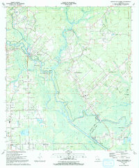
1991 Map of French Settlement
USGS Topo · Published 1991About this map
The Amite River meanders through a landscape defined by its complex hydrology and small riverside communities at the turn of the 1990s. This territory, straddling the border between Livingston Parish and Ascension Parish, reveals a network of waterways including Cocodrie Bayou and Colyell Bay that have shaped local settlement patterns for generations. The interior is dotted with cultural anchors such as Shiloh Ch, St Joseph Ch, and the Watson Cem in Port Vincent.
Find a feature on this map
67 named features on this map. Tap any name to fly to it.
Don’t see what you’re looking for? This feature index may not catch every label — zoom into the map to look around manually.
Map Details
Editions of this 1991 French Settlement Map
2 editions found
Other maps of this area

1892 · Mount Airy
USGS Topo · 1:62,500

1892 · Donaldsonville
USGS Topo · 1:62,500

1934 · Denham Springs
USGS Topo · 1:62,500

1934 · Springfield
USGS Topo · 1:62,500

1935 · Gonzales
USGS Topo · 1:31,680

1939 · Springfield
USGS Topo · 1:62,500

1939 · Denham Springs
USGS Topo · 1:62,500

1939 · Donaldsonville
USGS Topo · 1:62,500

1946 · Petite Amite River
USGS Topo · 1:31,680

1947 · Sorrento
USGS Topo · 1:31,680