
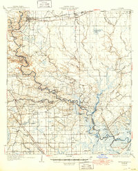
1934 Map of Denham Springs
USGS Topo · Published 1934About this map
The Amite River meanders through this 1930s landscape, serving as a natural boundary between Livingston Parish and East Baton Rouge Parish. The river's influence is evident in the dense network of bayous and lakes, including Fichlin Lake, Horseshoe Bend, and Lake Villars. Settlement patterns follow the higher ground and major transport lines, with the Illinois Central Railroad and State Highway No 190 cutting across the northern reaches through Denham Springs and Walker.
Find a feature on this map
112 named features on this map. Tap any name to fly to it.
Don’t see what you’re looking for? This feature index may not catch every label — zoom into the map to look around manually.
Map Details
Editions of this 1934 Denham Springs Map
2 editions found
Other maps of this area

1892 · Mount Airy
USGS Topo · 1:62,500

1892 · Donaldsonville
USGS Topo · 1:62,500

1906 · Bayou Sara
USGS Topo · 1:125,000

1908 · Baton Rouge
USGS Topo · 1:62,500

1934 · Springfield
USGS Topo · 1:62,500

1935 · Gonzales
USGS Topo · 1:31,680

1936 · White Castle
USGS Topo · 1:62,500

1939 · Springfield
USGS Topo · 1:62,500

1939 · Zachary
USGS Topo · 1:62,500

1939 · Denham Springs
USGS Topo · 1:62,500