1990s Maps of Gonzales, Louisiana
Explore 4 historic maps of Gonzales from the 1990s. These maps offer a rare glimpse into what life looked like during the 1990s — showing old roads, neighborhoods, homes, and landmarks that have changed or disappeared over time.
Whether you're researching your family's past, planning a metal detecting trip, or studying how Gonzales's landscape evolved across the 1990s, these high-resolution maps are a powerful tool for exploring the history of this region.
- Focus on a specific era: All maps on this page are from the 1990s, giving you a focused view of this time period.
- See what’s changed: Compare century-old streets, trails, and buildings to today's modern landscape using overlays and satellite layers.
- Research with precision: Use these maps for genealogy, historical research, land use analysis, or educational projects.
- View, download, or print: Maps are fully viewable online in high resolution, and can be downloaded or printed for your own records.
Start exploring Gonzales's history through authentic maps from the 1990s. This is your window into the past.
Gonzales, LA maps
(4)- 1991 Map of Gonzales
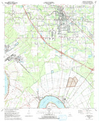 1991 Gonzales1991 Print · USGSAscension Parish is captured here in the early nineties as residential growth expanded outward from the river. Genealogists and local historians can trace family sites near Hope Haven Cem, the community at Hillaryville, and landmarks like Sacred Heart of Mary Ch.2 unique versions available
 - 1991 Map of Prairieville
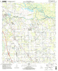
 1991 Prairieville1991 Print · USGSThe Ascension and East Baton Rouge Parish borderlands come alive in this early 1990s survey of the Bayou Manchac region. Trace family history through local landmarks like Prairieville Cem, St Amant, and Galvez Middle Sch.2 unique versions available
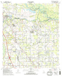
 - 1995 Map of Prairieville, 1998 Print
 1995 Prairieville1998 Print · USGSPrairieville and its neighboring settlements are captured in the mid-1990s during a period of steady residential growth between Baton Rouge and New Orleans. Genealogists and local historians can trace family landmarks like Richards Gardens of Memory Cem, the St John Ch, and the old crossroads at Hope Villa.
 - 1998 Map of Gonzales, 2001 Print
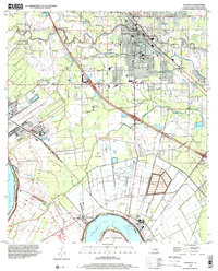 1998 Gonzales2001 Print · USGSAscension Parish at the close of the twentieth century shows a unique blend of riverfront industry and suburban growth near the Mississippi. Genealogists can locate family landmarks like Sacred Heart of Mary Ch, Burnside Cem, and the river-bend settlement of Hillaryville.
End of results
Showing maps 1-4 of 4
Top cities near Gonzales
- Baton Rouge historical maps
- St. George historical maps
- Saint George historical maps
- Prairieville historical maps
- Donaldsonville historical maps
- Lutcher historical maps
See more
Frequently asked questions
- What are the different types of historical maps available for Gonzales?
- What is the oldest map of Gonzales?
- Where can I purchase historical maps of Gonzales for my home or office?
- Where can I download high-res historical maps of Gonzales?
- Are there historical topographic maps available for Gonzales?
- Is there historical aerial imagery available for Gonzales?
- Where are historical maps of Gonzales sourced from?