1900s (20th Century) Maps of Egg Bend, Louisiana
Explore 7 historic maps of Egg Bend from the 1900s (20th Century). These maps offer a rare glimpse into what life looked like during the 1900s — showing old roads, neighborhoods, homes, and landmarks that have changed or disappeared over time.
Whether you're researching your family's past, planning a metal detecting trip, or studying how Egg Bend's landscape evolved across the 1900s, these high-resolution maps are a powerful tool for exploring the history of this region.
- Focus on a specific era: All maps on this page are from the 1900s, giving you a focused view of this time period.
- See what’s changed: Compare century-old streets, trails, and buildings to today's modern landscape using overlays and satellite layers.
- Research with precision: Use these maps for genealogy, historical research, land use analysis, or educational projects.
- View, download, or print: Maps are fully viewable online in high resolution, and can be downloaded or printed for your own records.
Start exploring Egg Bend's history through authentic maps from the 1900s. This is your window into the past.
Egg Bend, LA maps
(7)- 1940 Map of Marksville, 1943 Print
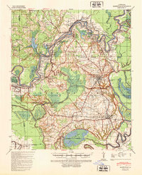 1940 Marksville1943 Print · USGSAvoyelles Parish life in the early 1940s is centered on the river-and-rail economy of the Red River valley. Genealogists and historians can trace family locations through numerous named churches and schools, such as Hickory Hill Sch, Vick, and the St Paul Ch & Cem.2 unique versions available
 - 1953 Map of Alexandria, 1963 Print
 1953 Alexandria1963 Print · USGSCentral Louisiana during the early fifties is mapped here at the intersection of the piney woods and the Red River valley. Genealogists and historians can trace the rail-and-river network connecting towns like Alexandria, Natchitoches, and the grounds of Camp Beauregard.3 unique versions available
 - 1955 Map of Alexandria
 1955 Alexandria1955 Print · USGSCentral Louisiana in the mid-fifties is a landscape of river-port cities, sprawling timberlands, and massive military reservations. Genealogists and historians can trace the rail networks of the Texas & Pacific RR and locate sites like Camp Polk Military Reservation and Natchitoches.
 - 1962 Map of Marksville, 1964 Print
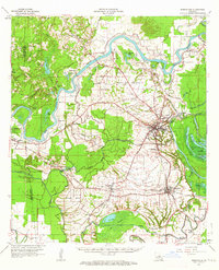 1962 Marksville1964 Print · USGSAvoyelles Parish in the early sixties remains a landscape shaped by river bends and rail lines before the modern highway era. Genealogists and historians can trace family locations near St Pauls Ch, Waddill Cem, and the historic Indian Mounds outside Marksville.3 unique versions available
 - 1983 Map of Effie
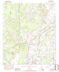 1983 Effie1983 Print · USGSAvoyelles and Rapides Parishes are shown in the early 1980s as a patchwork of bayous and small settlements along the Red River. Local historians can trace family roots at Pierce Cem, St Winifred Ch, and the rural center of Effie.
 - 1986 Map of Alexandria
 1986 Alexandria1986 Print · USGSCentral Louisiana in the mid-eighties shows a landscape of strategic military installations and deep river-valley agriculture. Researchers can trace the footprints of England Air Force Base, Camp Beauregard, and the extensive Kisatchie National Forest.2 unique versions available
 - 1993 Map of Effie
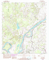 1993 Effie1993 Print · USGSAvoyelles and Rapides Parishes are shown in the early nineties as the Red River shapes the local landscape and culture. Genealogists and researchers can trace family landmarks like Pierce Cem, Hays Chapel, and the community of Fifth Ward along the river's southern banks.
End of results
Showing maps 1-7 of 7
Top cities near Egg Bend
- Alexandria historical maps
- Pineville historical maps
- Marksville historical maps
- Bunkie historical maps
- Cottonport historical maps
- Mansura historical maps
See more
Frequently asked questions
- What are the different types of historical maps available for Egg Bend?
- What is the oldest map of Egg Bend?
- Where can I purchase historical maps of Egg Bend for my home or office?
- Where can I download high-res historical maps of Egg Bend?
- Are there historical topographic maps available for Egg Bend?
- Is there historical aerial imagery available for Egg Bend?
- Where are historical maps of Egg Bend sourced from?