1940s Maps of DeRidder, Louisiana
Explore 2 historic maps of DeRidder from the 1940s. These maps offer a rare glimpse into what life looked like during the 1940s — showing old roads, neighborhoods, homes, and landmarks that have changed or disappeared over time.
Whether you're researching your family's past, planning a metal detecting trip, or studying how DeRidder's landscape evolved across the 1940s, these high-resolution maps are a powerful tool for exploring the history of this region.
- Focus on a specific era: All maps on this page are from the 1940s, giving you a focused view of this time period.
- See what’s changed: Compare century-old streets, trails, and buildings to today's modern landscape using overlays and satellite layers.
- Research with precision: Use these maps for genealogy, historical research, land use analysis, or educational projects.
- View, download, or print: Maps are fully viewable online in high resolution, and can be downloaded or printed for your own records.
Start exploring DeRidder's history through authentic maps from the 1940s. This is your window into the past.
DeRidder, LA maps
(2)- 1947 Map of DeRidder
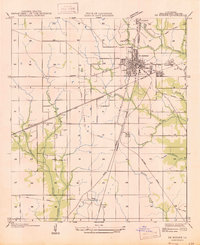 1947 DeRidder1947 Print · USGSBeauregard Parish in the mid-1940s was a critical juncture for the timber and rail industries. Genealogists and historians can locate defunct logging camps and community landmarks such as Grabow, Bon Ami, and the Old Hickman Sch along the Kansas City Southern tracks.
 - 1947 Map of Rosepine
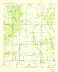 1947 Rosepine1947 Print · USGSLouisiana's western pine forests come into focus in the mid-1940s as the logging industry evolved along the rail corridors. Genealogists and researchers can trace the old paths between Neame and Rosepine, locating family landmarks like Walnut Grove Ch and Miller Cem.
End of results
Showing maps 1-2 of 2
Top cities near DeRidder
Top neighborhoods of DeRidder
Frequently asked questions
- What are the different types of historical maps available for DeRidder?
- What is the oldest map of DeRidder?
- Where can I purchase historical maps of DeRidder for my home or office?
- Where can I download high-res historical maps of DeRidder?
- Are there historical topographic maps available for DeRidder?
- Is there historical aerial imagery available for DeRidder?
- Where are historical maps of DeRidder sourced from?