1960s Maps of Dry Creek, Louisiana
Explore 2 historic maps of Dry Creek from the 1960s. These maps offer a rare glimpse into what life looked like during the 1960s — showing old roads, neighborhoods, homes, and landmarks that have changed or disappeared over time.
Whether you're researching your family's past, planning a metal detecting trip, or studying how Dry Creek's landscape evolved across the 1960s, these high-resolution maps are a powerful tool for exploring the history of this region.
- Focus on a specific era: All maps on this page are from the 1960s, giving you a focused view of this time period.
- See what’s changed: Compare century-old streets, trails, and buildings to today's modern landscape using overlays and satellite layers.
- Research with precision: Use these maps for genealogy, historical research, land use analysis, or educational projects.
- View, download, or print: Maps are fully viewable online in high resolution, and can be downloaded or printed for your own records.
Start exploring Dry Creek's history through authentic maps from the 1960s. This is your window into the past.
Dry Creek, LA maps
(2)- 1961 Map of Dry Creek, 1963 Print
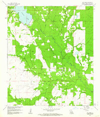 1961 Dry Creek1963 Print · USGSBeauregard Parish in the early sixties was a landscape of timber tracts and winding bayous centered on the community of Dry Creek. Genealogists and historians can trace the paths of an Old Railroad Grade or locate rural landmarks like Shiloh Ch and Green Cem.2 unique versions available
 - 1961 Map of Reeves, 1963 Print
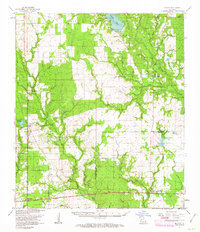 1961 Reeves1963 Print · USGSSouthwest Louisiana in the early sixties reveals a landscape of growing petroleum production and established rail junctions. Genealogists and local historians can trace family locations near Longville, Reeves, and Fulton, or find old landmarks like Magnolia Ch and Frusha Cem.2 unique versions available
End of results
Showing maps 1-2 of 2
Top cities near Dry Creek
Frequently asked questions
- What are the different types of historical maps available for Dry Creek?
- What is the oldest map of Dry Creek?
- Where can I purchase historical maps of Dry Creek for my home or office?
- Where can I download high-res historical maps of Dry Creek?
- Are there historical topographic maps available for Dry Creek?
- Is there historical aerial imagery available for Dry Creek?
- Where are historical maps of Dry Creek sourced from?