1980s Maps of Merryville, Louisiana
Explore 4 historic maps of Merryville from the 1980s. These maps offer a rare glimpse into what life looked like during the 1980s — showing old roads, neighborhoods, homes, and landmarks that have changed or disappeared over time.
Whether you're researching your family's past, planning a metal detecting trip, or studying how Merryville's landscape evolved across the 1980s, these high-resolution maps are a powerful tool for exploring the history of this region.
- Focus on a specific era: All maps on this page are from the 1980s, giving you a focused view of this time period.
- See what’s changed: Compare century-old streets, trails, and buildings to today's modern landscape using overlays and satellite layers.
- Research with precision: Use these maps for genealogy, historical research, land use analysis, or educational projects.
- View, download, or print: Maps are fully viewable online in high resolution, and can be downloaded or printed for your own records.
Start exploring Merryville's history through authentic maps from the 1980s. This is your window into the past.
Merryville, LA maps
(4)- 1982 Map of Merryville South, 1983 Print
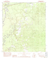 1982 Merryville South1983 Print · USGSThe Sabine River bottomlands in the early 1980s show a landscape shaped by shifting waters and rural settlement. Genealogists and local historians can trace legacy sites like Stark Cemetery, Lone Pine Church, and the community of Bivens.2 unique versions available
 - 1984 Map of Merryville North, 1985 Print
 1984 Merryville North1985 Print · USGSThe Sabine River bottomlands in the early eighties were a network of oxbow lakes and railroad corridors along the Texas border. Researchers can trace the path of the K. C. S. Ry. through Merryville and locate river features like Steamboat Bend and Horseshoe Lake.
 - 1986 Map of DeRidder
 1986 DeRidder1986 Print · USGSThe Louisiana-Texas borderlands come to life in the mid-eighties, showcasing the timber country and rail corridors of the Sabine River valley. Researchers can trace the legacy of small communities and transit lines through Merryville, Holly Springs, and the Missouri Pacific railroad.2 unique versions available
 - 1986 Map of Neale
 1986 Neale1986 Print · USGSIn the piney woods and wetlands along the Beauregard-Vernon Parish border in the 1980s, industry meets the bayou. Genealogists and researchers can trace the industrial footprint of Neale through its Refinery, Oil and Gas Field, and the Fire Break network.
End of results
Showing maps 1-4 of 4
Top cities near Merryville
Frequently asked questions
- What are the different types of historical maps available for Merryville?
- What is the oldest map of Merryville?
- Where can I purchase historical maps of Merryville for my home or office?
- Where can I download high-res historical maps of Merryville?
- Are there historical topographic maps available for Merryville?
- Is there historical aerial imagery available for Merryville?
- Where are historical maps of Merryville sourced from?