1950s Maps of Indian Hills Estates, Louisiana
Explore 4 historic maps of Indian Hills Estates from the 1950s. These maps offer a rare glimpse into what life looked like during the 1950s — showing old roads, neighborhoods, homes, and landmarks that have changed or disappeared over time.
Whether you're researching your family's past, planning a metal detecting trip, or studying how Indian Hills Estates's landscape evolved across the 1950s, these high-resolution maps are a powerful tool for exploring the history of this region.
- Focus on a specific era: All maps on this page are from the 1950s, giving you a focused view of this time period.
- See what’s changed: Compare century-old streets, trails, and buildings to today's modern landscape using overlays and satellite layers.
- Research with precision: Use these maps for genealogy, historical research, land use analysis, or educational projects.
- View, download, or print: Maps are fully viewable online in high resolution, and can be downloaded or printed for your own records.
Start exploring Indian Hills Estates's history through authentic maps from the 1950s. This is your window into the past.
Indian Hills Estates, LA maps
(4)- 1955 Map of Shreveport
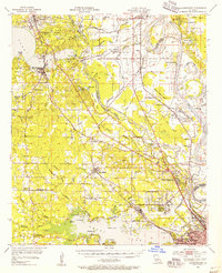
 1955 Shreveport1955 Print · USGSNorthern Louisiana in the mid-fifties is captured here as a landscape of military bases, vast oil fields, and burgeoning college towns. Genealogists and historians can trace the rail-and-river economy through the Monroe Gas Field, Grambling College, and Barksdale Air Force Base.3 unique versions available
 - 1955 Map of North Shreveport, 1956 Print
 1955 North Shreveport1956 Print · USGSShreveport's northern expansion is frozen in time during the mid-fifties as industrial rail lines and oil fields began to press into the Caddo Parish countryside. Genealogists can trace a wealth of community landmarks, from Walker Hill Cemetery to several rural schoolhouses like Center Point School and Round Grove School.
 - 1955 Map of Mooringsport, 1956 Print
 1955 Mooringsport1956 Print · USGSNorth of Shreveport in the mid-fifties, the landscape was a complex mix of active oil fields, bayou drainage projects, and rural plantations. Researchers can trace family sites at Sentell Plantation, Walker Hill Cem, or the Reed Spring Sch.3 unique versions available
 - 1956 Map of Shreveport
 1956 Shreveport1956 Print · USGSNorthern Louisiana during the mid-fifties presents a complex landscape of booming oil fields and strategic military installations. Genealogists and historians can trace the infrastructure of the Monroe Gas Field and family-named locales from Cotton Valley to Jonesboro.
End of results
Showing maps 1-4 of 4
Top cities near Indian Hills Estates
- Shreveport historical maps
- Bossier City historical maps
- Blanchard historical maps
- Greenwood historical maps
- Waskom historical maps
- Benton historical maps
See more
Frequently asked questions
- What are the different types of historical maps available for Indian Hills Estates?
- What is the oldest map of Indian Hills Estates?
- Where can I purchase historical maps of Indian Hills Estates for my home or office?
- Where can I download high-res historical maps of Indian Hills Estates?
- Are there historical topographic maps available for Indian Hills Estates?
- Is there historical aerial imagery available for Indian Hills Estates?
- Where are historical maps of Indian Hills Estates sourced from?