1980s Maps of Iowa, Louisiana
Explore 4 historic maps of Iowa from the 1980s. These maps offer a rare glimpse into what life looked like during the 1980s — showing old roads, neighborhoods, homes, and landmarks that have changed or disappeared over time.
Whether you're researching your family's past, planning a metal detecting trip, or studying how Iowa's landscape evolved across the 1980s, these high-resolution maps are a powerful tool for exploring the history of this region.
- Focus on a specific era: All maps on this page are from the 1980s, giving you a focused view of this time period.
- See what’s changed: Compare century-old streets, trails, and buildings to today's modern landscape using overlays and satellite layers.
- Research with precision: Use these maps for genealogy, historical research, land use analysis, or educational projects.
- View, download, or print: Maps are fully viewable online in high resolution, and can be downloaded or printed for your own records.
Start exploring Iowa's history through authentic maps from the 1980s. This is your window into the past.
Iowa, LA maps
(4)- 1985 Map of Fenton
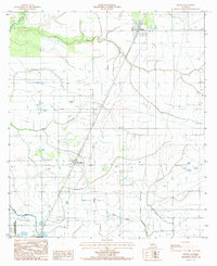 1985 Fenton1985 Print · USGSJefferson Davis Parish in the mid-eighties shows a landscape defined by its bayous and agricultural infrastructure. Trace the early layout of Fenton and Woodlawn or locate rural features like the Cem and various Radio Towers among the irrigation flumes.
 - 1985 Map of Lacassine
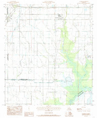 1985 Lacassine1985 Print · USGSCoastal prairie life in the mid-eighties was defined by the rail lines and irrigation canals that shaped Jefferson Davis Parish. Researchers can trace the dual tracks of the Southern Pacific and Missouri Pacific or locate the rural Cem and Verret settlement.2 unique versions available
 - 1985 Map of Crowley, 1986 Print
 1985 Crowley1986 Print · USGSCoastal prairie and bayou country are captured in the mid-eighties as the rice-and-rail economy defined South Louisiana life. Genealogists and researchers can trace family lands and rural hubs from Crowley to Jennings, following the paths of the Southern Pacific Railroad and the winding Mermentau River.2 unique versions available
 - 1986 Map of Lake Charles
 1986 Lake Charles1986 Print · USGSThe Louisiana-Texas borderlands are captured here in the mid-1980s, showcasing the industrial growth of the Lake Charles region and its rail-linked satellite towns. Trace the evolution of coastal settlements and family landmarks from Sulphur to the Highland Cem.2 unique versions available
End of results
Showing maps 1-4 of 4
Top cities near Iowa
- Lake Charles historical maps
- Welsh historical maps
- Kinder historical maps
- Hayes historical maps
- Fenton historical maps
Frequently asked questions
- What are the different types of historical maps available for Iowa?
- What is the oldest map of Iowa?
- Where can I purchase historical maps of Iowa for my home or office?
- Where can I download high-res historical maps of Iowa?
- Are there historical topographic maps available for Iowa?
- Is there historical aerial imagery available for Iowa?
- Where are historical maps of Iowa sourced from?