1990s Maps of Vincent Landing, Louisiana
Explore 2 historic maps of Vincent Landing from the 1990s. These maps offer a rare glimpse into what life looked like during the 1990s — showing old roads, neighborhoods, homes, and landmarks that have changed or disappeared over time.
Whether you're researching your family's past, planning a metal detecting trip, or studying how Vincent Landing's landscape evolved across the 1990s, these high-resolution maps are a powerful tool for exploring the history of this region.
- Focus on a specific era: All maps on this page are from the 1990s, giving you a focused view of this time period.
- See what’s changed: Compare century-old streets, trails, and buildings to today's modern landscape using overlays and satellite layers.
- Research with precision: Use these maps for genealogy, historical research, land use analysis, or educational projects.
- View, download, or print: Maps are fully viewable online in high resolution, and can be downloaded or printed for your own records.
Start exploring Vincent Landing's history through authentic maps from the 1990s. This is your window into the past.
Vincent Landing, LA maps
(2)- 1994 Map of Westlake, 1996 Print
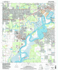 1994 Westlake1996 Print · USGSThe industrial and maritime heart of Calcasieu Parish is revealed here during the mid-nineties, showing the intersection of heavy industry and residential growth. Genealogists and historians can locate family plots at Farquerar Cem and Burleson Cem or trace the early waterfront at Vincent Landing.
 - 1996 Map of Westlake, 1999 Print
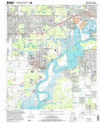 1996 Westlake1999 Print · USGSThe Calcasieu River waterfront was a hub of petrochemical industry and maritime commerce in the mid-nineties. Genealogists and historians can trace family locations through Farquarer Cem or the settlements of Mossville and Vincent Landing.
End of results
Showing maps 1-2 of 2
Top cities near Vincent Landing
Frequently asked questions
- What are the different types of historical maps available for Vincent Landing?
- What is the oldest map of Vincent Landing?
- Where can I purchase historical maps of Vincent Landing for my home or office?
- Where can I download high-res historical maps of Vincent Landing?
- Are there historical topographic maps available for Vincent Landing?
- Is there historical aerial imagery available for Vincent Landing?
- Where are historical maps of Vincent Landing sourced from?