1980s Maps of Ferriday, Louisiana
Explore 3 historic maps of Ferriday from the 1980s. These maps offer a rare glimpse into what life looked like during the 1980s — showing old roads, neighborhoods, homes, and landmarks that have changed or disappeared over time.
Whether you're researching your family's past, planning a metal detecting trip, or studying how Ferriday's landscape evolved across the 1980s, these high-resolution maps are a powerful tool for exploring the history of this region.
- Focus on a specific era: All maps on this page are from the 1980s, giving you a focused view of this time period.
- See what’s changed: Compare century-old streets, trails, and buildings to today's modern landscape using overlays and satellite layers.
- Research with precision: Use these maps for genealogy, historical research, land use analysis, or educational projects.
- View, download, or print: Maps are fully viewable online in high resolution, and can be downloaded or printed for your own records.
Start exploring Ferriday's history through authentic maps from the 1980s. This is your window into the past.
Ferriday, LA maps
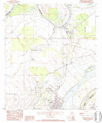
(3)- 1983 Map of Ferriday South, 1984 Print
 1983 Ferriday South1984 Print · USGSThe alluvial plains of Concordia Parish and Adams County are captured here in the early 1980s. Genealogists can locate family landmarks like Lambert Cem and Sawyer Cem or churches including Shady Acres Ch and St Thomas Ch.
 - 1983 Map of Ferriday North, 1984 Print
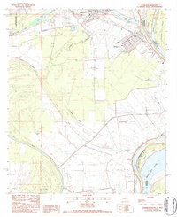
 1983 Ferriday North1984 Print · USGSThe delta country of Concordia Parish is captured here in the early 1980s as the river economy and rail lines shaped local life. Researchers can trace family history through sites like Hill Memorial Ch, Rogers Cem, and the neighborhoods of Ferriday.2 unique versions available
 - 1984 Map of Natchez
 1984 Natchez1984 Print · USGSThe Mississippi-Louisiana borderlands in the mid-eighties show a landscape defined by the winding Mississippi River and its rail networks. Trace family history at the Natchez National Cemetery or explore the river towns of Vidalia and Ferriday.
End of results
Showing maps 1-3 of 3
Top cities near Ferriday
- Natchez historical maps
- Vidalia historical maps
- Ridgecrest historical maps
- Clayton historical maps
- Waterproof historical maps
- Sicily Island historical maps
Frequently asked questions
- What are the different types of historical maps available for Ferriday?
- What is the oldest map of Ferriday?
- Where can I purchase historical maps of Ferriday for my home or office?
- Where can I download high-res historical maps of Ferriday?
- Are there historical topographic maps available for Ferriday?
- Is there historical aerial imagery available for Ferriday?
- Where are historical maps of Ferriday sourced from?