Old Maps of Concordia Parish, Louisiana for Metal Detecting
Plan your next treasure hunt with 196 historic maps of Concordia Parish. Find old homesites, ghost towns, trails, and gathering spots that may be lost to time — perfect for identifying promising metal detecting locations.
- Locate forgotten sites: Uncover places like long-lost settlements, abandoned rail lines, or gathering spots.
- Plan better hunts: Use map overlays combined with LiDAR or satellite views to narrow in on historically rich areas.
- Made for detectorists: Thousands of hobbyists use these maps to discover relics, coins, and hidden history.
Use these historic maps to boost your research and find new opportunities beneath the surface of Concordia Parish.
Concordia Parish, LA maps
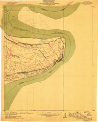
(196)- 1909 Map of Sycamore Landing
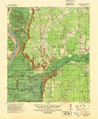
 1909 Sycamore Landing1909 Print · USGSThe riverfront of Concordia Parish comes alive in the early twentieth century as plantations and rail lines intersect along the Mississippi. Genealogists and historians can trace family roots at Lucerna Plantation or locate community centers like Rufus Baptist Church and Morville.
 - 1909 Map of Vidalia
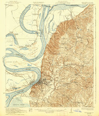
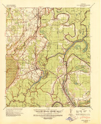
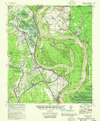
 1909 Vidalia1909 Print · USGSConcordia Parish sits at a tight bend of the Mississippi River in the early 1900s, where plantation life and rail commerce intersect. Genealogists and local historians can trace the foundations of Vidalia or locate family-named sites like Taconey Plantation and Minorca Church.
 - 1921 Map of Natchez
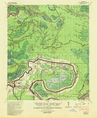
 1921 Natchez1921 Print · USGSThe Mississippi River bluffs and floodplain come alive in this early 1920s survey of the Natchez region and its Louisiana neighbors. Genealogists can trace family roots through numerous sites like Taconey Plantation, the Adams County Poor Farm, and Quitman School.
 - 1922 Map of Natchez, 1938 Print
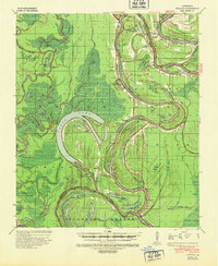
 1922 Natchez1938 Print · USGSThe Mississippi River's shifting path at Natchez in the early twentieth century reveals a landscape of working plantations and thriving river ports. Researchers can trace land holdings at Windemere, locate rural sites like the Poor Farm, or follow the Yazoo and Mississippi Valley rail line.2 unique versions available
 - 1935 Map of Tooleys, 1936 Print
 1935 Tooleys1936 Print · USGSThe alluvial wetlands of Concordia and Catahoula Parishes are documented here during the mid-1930s when river life revolved around local landings. Researchers can trace family roots at Larto Sch, identify ancestral sites near the B M Graveyard, or locate early homesteads by Island Bayou Ldg.
 - 1939 Map of Red Gum, 1941 Print
 1939 Red Gum1941 Print · USGSConcordia Parish sits at a vital rail and river junction during the late thirties. Researchers can locate numerous historic landings and community pillars like the Rosenwald Sch, New St John Ch, and the crossroads at Ferriday.2 unique versions available
 - 1939 Map of Natchez, 1943 Print
 1939 Natchez1943 Print · USGSThe Mississippi River corridor and Natchez area appear in the late thirties as a landscape of river-bottom plantations and bluff-top estates. Genealogists can locate family landmarks like Hole in the Wall Plantation, Briars Plantation, and Gilfield Ch & Sch.3 unique versions available
 - 1939 Map of Kingston, 1944 Print
 1939 Kingston1944 Print · USGSThe bluffs and bayous of Adams and Wilkinson Counties are captured here in the late 1930s just as the national forest was expanding. Genealogists and researchers can trace family landmarks like Beverly Plantation, Rose Hill Ch & Cem, and the community of Kingston.2 unique versions available
 - 1939 Map of Artonish, 1945 Print
 1939 Artonish1945 Print · USGSThe river-and-rail economy of the Louisiana-Mississippi border is frozen in time just before the mid-century, showing the dense settlement of the bottomlands. Genealogists can trace family roots through numerous local landmarks like Fort Adams, Singleton Chapel & Cem, and the Black Hawk Plantation.
 - 1939 Map of Deer Park, 1951 Print
 1939 Deer Park1951 Print · USGSThe Lower Mississippi River valley in the late thirties reveals a landscape of massive plantations and shifting river bends. Genealogists and historians can trace family land in Moro Plantation, locate schools like Central High School, or find small settlements such as Monterey and Arnot.
 - 1939 Map of Locust Ridge, 1965 Print
 1939 Locust Ridge1965 Print · USGSThe Mississippi Delta in the late 1930s reveals a land of sprawling plantations and bayou settlements along the Louisiana border. Genealogists can trace family landmarks like the Mayflower Cem, Maryland Plantation Cem, and New St Mark Ch among the meanders of the river.
 - 1941 Map of Manifest, 1943 Print
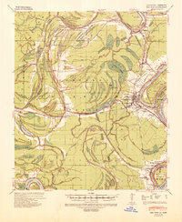
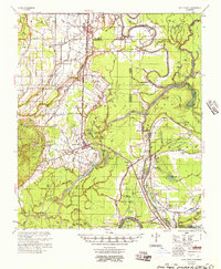
 1941 Manifest1943 Print · USGSCatahoula Parish in the early 1940s is defined by its strategic river junctions and a sprawling network of bayous. Researchers can trace the riverfront development of Jonesville and Trinity or locate rural landmarks like Bethel Ch and the Indian Mound.
 - 1941 Map of Sicily Island, 1943 Print
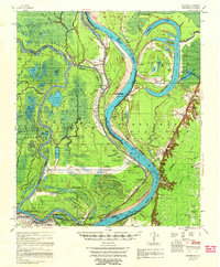
 1941 Sicily Island1943 Print · USGSLouisiana's delta country comes alive in the 1940s as a complex network of bayous, landings, and rail lines. Genealogists and historians can trace the foundations of local life through rural landmarks like Sunnyside Sch & Ch, several Indian Mounds, and the Missouri Pacific rail corridor.2 unique versions available
 - 1941 Map of Voorhies, 1943 Print
 1941 Voorhies1943 Print · USGSAvoyelles Parish is captured here in the early 1940s, showcasing a river-bound landscape shaped by the Red River and its many oxbows. Genealogists can trace family roots through numerous landmarks like St James Ch & Cem, Voorhies School, and Moreauville.2 unique versions available
 - 1941 Map of Batchelor, 1944 Print
 1941 Batchelor1944 Print · USGSThe Mississippi River's powerful shifts define this corner of Louisiana in the early 1940s, from the oxbows of the Raccourci Old River to the banks of Angola. Local researchers can locate family landmarks such as Mains Plantation, St Stevens Ch, and the Lower Latanache Sch.
 - 1941 Map of Tooleys, 1946 Print
 1941 Tooleys1946 Print · USGSLouisiana's river country comes to life in the 1940s as the confluence of the Black and Red Rivers shapes the delta parishes. Genealogists and historians can locate numerous landings like McDonald Ldg, local schools including Boggy Bayou Sch, and the Indian Mounds.2 unique versions available
 - 1953 Map of Natchez, 1966 Print
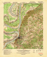
 1953 Natchez1966 Print · USGSSouthwest Mississippi and the Louisiana border country come alive in this mid-century survey of the river valley and forest lands. Researchers can trace the rail lines of the Illinois Central RR and locate rural hubs like Gloster and Ferriday.3 unique versions available
 - 1954 Map of Artonish, 1966 Print
 1954 Artonish1966 Print · USGSThe riverfronts of Concordia Parish and Wilkinson County are captured here in the mid-fifties, during a period of significant hydraulic engineering and transition. Genealogists and historians can trace family-named sites like Shaw Plantation, Singleton Cem, and the old military outpost at Fort Adams.
 - 1954 Map of Baton Rouge, 1974 Print
 1954 Baton Rouge1974 Print · USGSSoutheast Louisiana in the mid-fifties is captured here during a period of transition for its river and rail economies. Researchers can trace the path of the Mississippi River and find landmarks like the Bonnet Carre Spillway and Bayou Plaquemine.2 unique versions available
 - 1955 Map of Artonish
 1955 Artonish1955 Print · USGSWilkinson County and Concordia Parish in the mid-fifties are defined here by the massive plantations and river landings along the winding Mississippi River. Genealogists can trace local roots through numerous sites like Royal Oak Ch & Cem, Fort Adams, and the Torras Community Sch.
 - 1955 Map of Batchelor
 1955 Batchelor1955 Print · USGSLouisiana's river country is captured here in the mid-fifties, showing the massive impact of cutoffs and flood control projects on local parishes. Researchers can trace the sprawling Penitentiary Farm at Angola or locate family roots at St Marys Ch & Cem and Lacour Plantation.
 - 1956 Map of Natchez
 1956 Natchez1956 Print · USGSThe Mississippi River borderlands and the Pine Hills come alive in this mid-fifties study of the Natchez region. Genealogists and historians can trace rail-era towns along the Illinois Central RR and explore the oxbows of Lake Bruin and Lake Concordia.
 - 1956 Map of Baton Rouge
 1956 Baton Rouge1956 Print · USGSSouth Louisiana at the height of the mid-century oil boom shows a landscape of river oxbows and rising industry. Researchers can trace family roots through river towns like Scotlandville or locate early industrial sites and Oil wells near Lake Maurepas.
 - 1957 Map of Sicily Island
 1957 Sicily Island1957 Print · USGSCatahoula Parish and the surrounding lowlands are captured in the late 1950s, showing a landscape shaped by the Tensas River and its many bayous. Genealogists can trace family roots at New Zion Ch & Cem 37, Loam Land Sch & Cem, or the old Lee Bayou School House.2 unique versions available
 - 1958 Map of Artonish
 1958 Artonish1958 Print · USGSThe river bluffs of Mississippi and the bottomlands of Louisiana meet here in the late fifties as massive engineering projects began to reshape the landscape. Local historians can trace family-named sites like Stamps Plantation or locate rural landmarks such as Royal Oak Ch & Cem and the Texas and Pacific RR.
Showing maps 1-25 of 196
Top cities of Concordia Parish
Frequently asked questions
- What are the different types of historical maps available for Concordia Parish?
- What is the oldest map of Concordia Parish?
- Where can I purchase historical maps of Concordia Parish for my home or office?
- Where can I download high-res historical maps of Concordia Parish?
- Are there historical topographic maps available for Concordia Parish?
- Is there historical aerial imagery available for Concordia Parish?
- Where are historical maps of Concordia Parish sourced from?