1980s Maps of Logansport, Louisiana
Explore 7 historic maps of Logansport from the 1980s. These maps offer a rare glimpse into what life looked like during the 1980s — showing old roads, neighborhoods, homes, and landmarks that have changed or disappeared over time.
Whether you're researching your family's past, planning a metal detecting trip, or studying how Logansport's landscape evolved across the 1980s, these high-resolution maps are a powerful tool for exploring the history of this region.
- Focus on a specific era: All maps on this page are from the 1980s, giving you a focused view of this time period.
- See what’s changed: Compare century-old streets, trails, and buildings to today's modern landscape using overlays and satellite layers.
- Research with precision: Use these maps for genealogy, historical research, land use analysis, or educational projects.
- View, download, or print: Maps are fully viewable online in high resolution, and can be downloaded or printed for your own records.
Start exploring Logansport's history through authentic maps from the 1980s. This is your window into the past.
Logansport, LA maps
(7)- 1984 Map of Shreveport
 1984 Shreveport1984 Print · USGSNorthern Louisiana at the peak of the 1980s reveals a landscape of massive water management projects and Cold War military hubs. Trace the rail lines of the Kansas City Southern Ry past Barksdale Air Force Base and the high ground of Driskill Mountain.2 unique versions available
 - 1984 Map of Logansport East
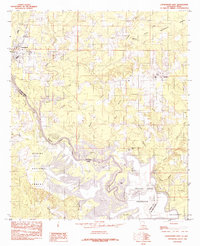 1984 Logansport East1984 Print · USGSThe Louisiana-Texas borderlands in the early eighties were defined by the rising waters of the Toledo Bend Reservoir. Local historians can trace the creek-side settlements of Stanley and Logansport or locate family-named landmarks like Cawthorn Lake and Southerland Bottom.
 - 1984 Map of Palestine
 1984 Palestine1984 Print · USGSEast Texas in the mid-eighties reveals a landscape of massive reservoirs and protected timberlands between Palestine and Nacogdoches. Researchers can trace old routes like the Missouri Pacific RR and locate rural communities such as Tennessee Colony, Latexo, and Etoile.3 unique versions available
 - 1984 Map of Logansport West
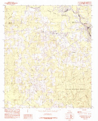 1984 Logansport West1984 Print · USGSThe borderlands along the Sabine River in the mid-1980s show a region shaped by timber and the Toledo Bend Reservoir. Local researchers can trace family lands near Joaquin, Logansport, and the rural community of Fellowship.
 - 1985 Map of Shreveport South
 1985 Shreveport South1985 Print · USGSNorthwest Louisiana in the mid-eighties shows a landscape defined by the Red River and a transition from urban centers to deep timberland. Researchers can trace the rail-and-river economy through landmarks like Barksdale Air Force Base, the Sligo Oil and Gas Field, and Lake Bistineau.2 unique versions available
 - 1986 Map of Natchitoches
 1986 Natchitoches1986 Print · USGSNorthwestern Louisiana during the mid-eighties shows a landscape shaped by major water projects and timberlands. Researchers can trace historic routes like the Old Spanish Trail or locate rural communities such as Fort Jesup, Fairview Alpha, and Grappes Bluff.2 unique versions available
 - 1986 Map of Nacogdoches
 1986 Nacogdoches1986 Print · USGSDeep in the East Texas Piney Woods during the mid-eighties, this landscape centers on Nacogdoches and the sprawling Toledo Bend Reservoir. Genealogists can trace family footprints at Sulphur Springs Cem, Oak Grove Ch, and the many small settlements like Reklaw and Sacul.
End of results
Showing maps 1-7 of 7
Top cities near Logansport
- Center historical maps
- Tenaha historical maps
- Joaquin historical maps
- Huxley historical maps
- Grand Cane historical maps
- Longstreet historical maps
See more
Frequently asked questions
- What are the different types of historical maps available for Logansport?
- What is the oldest map of Logansport?
- Where can I purchase historical maps of Logansport for my home or office?
- Where can I download high-res historical maps of Logansport?
- Are there historical topographic maps available for Logansport?
- Is there historical aerial imagery available for Logansport?
- Where are historical maps of Logansport sourced from?