1900s (20th Century) Maps of Logansport, Louisiana
Explore 21 historic maps of Logansport from the 1900s (20th Century). These maps offer a rare glimpse into what life looked like during the 1900s — showing old roads, neighborhoods, homes, and landmarks that have changed or disappeared over time.
Whether you're researching your family's past, planning a metal detecting trip, or studying how Logansport's landscape evolved across the 1900s, these high-resolution maps are a powerful tool for exploring the history of this region.
- Focus on a specific era: All maps on this page are from the 1900s, giving you a focused view of this time period.
- See what’s changed: Compare century-old streets, trails, and buildings to today's modern landscape using overlays and satellite layers.
- Research with precision: Use these maps for genealogy, historical research, land use analysis, or educational projects.
- View, download, or print: Maps are fully viewable online in high resolution, and can be downloaded or printed for your own records.
Start exploring Logansport's history through authentic maps from the 1900s. This is your window into the past.
Logansport, LA maps
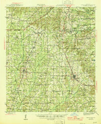
(21)- 1944 Map of Logansport
 1944 Logansport1944 Print · USGSDe Soto and Sabine Parishes are shown in the early 1940s as the Sabine River snakes through a landscape of bayous and forest. Genealogists and local historians can trace family roots through numerous sites like Prude Cem, Morning Glory Sch, and Pauls Store.
 - 1945 Map of Grand Cane
 1945 Grand Cane1945 Print · USGSDe Soto Parish during the mid-1940s is defined by its rural settlements and sprawling agricultural estates. Researchers can locate numerous local landmarks including the Longstreet Rosenwald School, Park Dots Plantation, and Smyrna Church.
 - 1953 Map of Alexandria, 1963 Print
 1953 Alexandria1963 Print · USGSCentral Louisiana during the early fifties is mapped here at the intersection of the piney woods and the Red River valley. Genealogists and historians can trace the rail-and-river network connecting towns like Alexandria, Natchitoches, and the grounds of Camp Beauregard.3 unique versions available
 - 1953 Map of Palestine, 1964 Print
 1953 Palestine1964 Print · USGSEast Texas was defined by its deep pine forests and burgeoning energy sector in the mid-1950s. Genealogists and historians can trace the rail-and-river economy through settlements like Tennessee Colony and Pollok or explore the early footprints of the Cayuga Oil Field and Davy Crockett National Forest.2 unique versions available
 - 1955 Map of Shreveport
 1955 Shreveport1955 Print · USGSNorthern Louisiana in the mid-fifties is captured here as a landscape of military bases, vast oil fields, and burgeoning college towns. Genealogists and historians can trace the rail-and-river economy through the Monroe Gas Field, Grambling College, and Barksdale Air Force Base.3 unique versions available
 - 1955 Map of Alexandria
 1955 Alexandria1955 Print · USGSCentral Louisiana in the mid-fifties is a landscape of river-port cities, sprawling timberlands, and massive military reservations. Genealogists and historians can trace the rail networks of the Texas & Pacific RR and locate sites like Camp Polk Military Reservation and Natchitoches.
 - 1956 Map of Shreveport
 1956 Shreveport1956 Print · USGSNorthern Louisiana during the mid-fifties presents a complex landscape of booming oil fields and strategic military installations. Genealogists and historians can trace the infrastructure of the Monroe Gas Field and family-named locales from Cotton Valley to Jonesboro.
 - 1956 Map of Logansport, 1957 Print
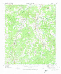
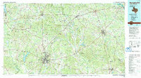
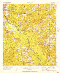 1956 Logansport1957 Print · USGSDe Soto Parish and the Texas borderlands come alive in this mid-century survey of the Sabine River valley. Genealogists can trace local landmarks like Pauls Store, Mt Olivet Ch, and the Third Ward Sch across a landscape of rails and river bends.4 unique versions available
 - 1957 Map of Grand Cane
 1957 Grand Cane1957 Print · USGSMid-century De Soto Parish comes into focus through its rural schools, plantations, and rail-side villages. Genealogists can trace family landmarks like Park Dota Plantation, the Longstreet Rosenwald Sch, and many churches including New Zion Ch.2 unique versions available
 - 1957 Map of Palestine
 1957 Palestine1957 Print · USGSEast Texas in the mid-fifties reveals a landscape of deep pine forests and winding river valleys before the era of massive reservoir construction. Researchers can trace the legacy of the timber and rail industries through labels for the Missouri Pacific RR, Davy Crockett National Forest, and Nacogdoches.
 - 1958 Map of Center, 1959 Print
 1958 Center1959 Print · USGSShelby County in the late fifties remains a landscape of timbered hills and rail-connected crossroads. Researchers can trace family roots through numerous rural sites like Newhope Ch, Union Cem, and the small community of Shelbyville near the Sabine River.3 unique versions available
 - 1972 Map of Grand Cane, 1974 Print
 1972 Grand Cane1974 Print · USGSDe Soto and Caddo Parishes in the early 1970s reveal a landscape of rural plantation legacies and an expanding oil and gas industry. Genealogists can trace family names through dozens of landmarks like Roseneath Plantation, Mary Evergreen Ch, and the Fullalove Cem.
 - 1972 Map of Longstreet, 1974 Print
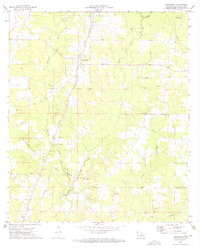 1972 Longstreet1974 Print · USGSDe Soto Parish in the early seventies is a landscape of rural settlements and growing energy infrastructure. Genealogists and historians can trace family-named sites like Gamble Cem and Union Vine Ch alongside the Southern Pacific rail line.
 - 1984 Map of Shreveport
 1984 Shreveport1984 Print · USGSNorthern Louisiana at the peak of the 1980s reveals a landscape of massive water management projects and Cold War military hubs. Trace the rail lines of the Kansas City Southern Ry past Barksdale Air Force Base and the high ground of Driskill Mountain.2 unique versions available
 - 1984 Map of Logansport East
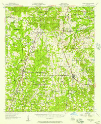
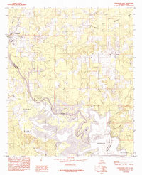 1984 Logansport East1984 Print · USGSThe Louisiana-Texas borderlands in the early eighties were defined by the rising waters of the Toledo Bend Reservoir. Local historians can trace the creek-side settlements of Stanley and Logansport or locate family-named landmarks like Cawthorn Lake and Southerland Bottom.
 - 1984 Map of Palestine
 1984 Palestine1984 Print · USGSEast Texas in the mid-eighties reveals a landscape of massive reservoirs and protected timberlands between Palestine and Nacogdoches. Researchers can trace old routes like the Missouri Pacific RR and locate rural communities such as Tennessee Colony, Latexo, and Etoile.3 unique versions available
 - 1984 Map of Logansport West
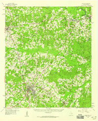
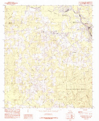 1984 Logansport West1984 Print · USGSThe borderlands along the Sabine River in the mid-1980s show a region shaped by timber and the Toledo Bend Reservoir. Local researchers can trace family lands near Joaquin, Logansport, and the rural community of Fellowship.
 - 1985 Map of Shreveport South
 1985 Shreveport South1985 Print · USGSNorthwest Louisiana in the mid-eighties shows a landscape defined by the Red River and a transition from urban centers to deep timberland. Researchers can trace the rail-and-river economy through landmarks like Barksdale Air Force Base, the Sligo Oil and Gas Field, and Lake Bistineau.2 unique versions available
 - 1986 Map of Natchitoches
 1986 Natchitoches1986 Print · USGSNorthwestern Louisiana during the mid-eighties shows a landscape shaped by major water projects and timberlands. Researchers can trace historic routes like the Old Spanish Trail or locate rural communities such as Fort Jesup, Fairview Alpha, and Grappes Bluff.2 unique versions available
 - 1986 Map of Nacogdoches
 1986 Nacogdoches1986 Print · USGSDeep in the East Texas Piney Woods during the mid-eighties, this landscape centers on Nacogdoches and the sprawling Toledo Bend Reservoir. Genealogists can trace family footprints at Sulphur Springs Cem, Oak Grove Ch, and the many small settlements like Reklaw and Sacul.
 - 1992 Map of Nacogdoches
 1992 Nacogdoches1992 Print · USGSEast Texas timberlands and river valleys are captured here in the early nineties, centered on the historic regional hub of Nacogdoches. Trace family roots and old rail lines through Cushing, San Augustine, and Logansport along the Southern Pacific RR.
End of results
Showing maps 1-21 of 21
Top cities near Logansport
- Center historical maps
- Tenaha historical maps
- Joaquin historical maps
- Huxley historical maps
- Grand Cane historical maps
- Longstreet historical maps
See more
Frequently asked questions
- What are the different types of historical maps available for Logansport?
- What is the oldest map of Logansport?
- Where can I purchase historical maps of Logansport for my home or office?
- Where can I download high-res historical maps of Logansport?
- Are there historical topographic maps available for Logansport?
- Is there historical aerial imagery available for Logansport?
- Where are historical maps of Logansport sourced from?