1990s Maps of Lakeland Terrace, St. George
Explore 2 historic maps of Lakeland Terrace from the 1990s. These maps offer a rare glimpse into what life looked like during the 1990s — showing old roads, neighborhoods, homes, and landmarks that have changed or disappeared over time.
Whether you're researching your family's past, planning a metal detecting trip, or studying how Lakeland Terrace's landscape evolved across the 1990s, these high-resolution maps are a powerful tool for exploring the history of this region.
- Focus on a specific era: All maps on this page are from the 1990s, giving you a focused view of this time period.
- See what’s changed: Compare century-old streets, trails, and buildings to today's modern landscape using overlays and satellite layers.
- Research with precision: Use these maps for genealogy, historical research, land use analysis, or educational projects.
- View, download, or print: Maps are fully viewable online in high resolution, and can be downloaded or printed for your own records.
Start exploring Lakeland Terrace's history through authentic maps from the 1990s. This is your window into the past.
Lakeland Terrace, St. George maps
(2)- 1992 Map of St. Gabriel
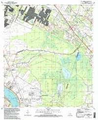 1992 St. Gabriel1992 Print · USGSThe river parishes south of Baton Rouge were a landscape of heavy industry and institutional centers in the early nineties. Genealogists and local researchers can trace the connections between St Gabriel and its historic St Raphael Cem, or locate landmarks like Iberville (Bayou Paul Sta).
 - 1995 Map of St. Gabriel, 1998 Print
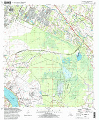 1995 St. Gabriel1998 Print · USGSLouisiana's River Parishes meet the edge of the state capital in the late twentieth century, showing a landscape of bayous and industrial growth. Researchers can trace historic sites like St Gabriel Mission, the St Raphael Cem, and the rail stop at Iberville (Bayou Paul Sta).
End of results
Showing maps 1-2 of 2
Top cities near Lakeland Terrace
- Baton Rouge historical maps
- Saint George historical maps
- St. George historical maps
- Prairieville historical maps
- Central historical maps
- Baker historical maps
See more
Frequently asked questions
- What are the different types of historical maps available for Lakeland Terrace?
- What is the oldest map of Lakeland Terrace?
- Where can I purchase historical maps of Lakeland Terrace for my home or office?
- Where can I download high-res historical maps of Lakeland Terrace?
- Are there historical topographic maps available for Lakeland Terrace?
- Is there historical aerial imagery available for Lakeland Terrace?
- Where are historical maps of Lakeland Terrace sourced from?