1930s Maps of Aloha, Louisiana
Explore 2 historic maps of Aloha from the 1930s. These maps offer a rare glimpse into what life looked like during the 1930s — showing old roads, neighborhoods, homes, and landmarks that have changed or disappeared over time.
Whether you're researching your family's past, planning a metal detecting trip, or studying how Aloha's landscape evolved across the 1930s, these high-resolution maps are a powerful tool for exploring the history of this region.
- Focus on a specific era: All maps on this page are from the 1930s, giving you a focused view of this time period.
- See what’s changed: Compare century-old streets, trails, and buildings to today's modern landscape using overlays and satellite layers.
- Research with precision: Use these maps for genealogy, historical research, land use analysis, or educational projects.
- View, download, or print: Maps are fully viewable online in high resolution, and can be downloaded or printed for your own records.
Start exploring Aloha's history through authentic maps from the 1930s. This is your window into the past.
Aloha, LA maps
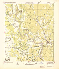
(2)- 1937 Map of Aloha
 1937 Aloha1937 Print · USGSLouisiana's river country comes into focus in the 1930s as the Red River and Cane River carve through these rural parishes. Genealogists can locate family-named landmarks like Rachel Cem, Abrahams Sch, and the community of Aloha.
 - 1937 Map of Montgomery
 1937 Montgomery1937 Print · USGSThe Red River valley in the late thirties is captured here at the junction of three parishes during a period of active river commerce. Trace family roots and local history at Montgomery, Creola Cem, and rural school sites like Ebenezer Sch or Borden Sch.
End of results
Showing maps 1-2 of 2
Top cities near Aloha
- Alexandria historical maps
- Colfax historical maps
- Boyce historical maps
- Montgomery historical maps
- Atlanta historical maps
Frequently asked questions
- What are the different types of historical maps available for Aloha?
- What is the oldest map of Aloha?
- Where can I purchase historical maps of Aloha for my home or office?
- Where can I download high-res historical maps of Aloha?
- Are there historical topographic maps available for Aloha?
- Is there historical aerial imagery available for Aloha?
- Where are historical maps of Aloha sourced from?