1980s Maps of Aloha, Louisiana
Explore 2 historic maps of Aloha from the 1980s. These maps offer a rare glimpse into what life looked like during the 1980s — showing old roads, neighborhoods, homes, and landmarks that have changed or disappeared over time.
Whether you're researching your family's past, planning a metal detecting trip, or studying how Aloha's landscape evolved across the 1980s, these high-resolution maps are a powerful tool for exploring the history of this region.
- Focus on a specific era: All maps on this page are from the 1980s, giving you a focused view of this time period.
- See what’s changed: Compare century-old streets, trails, and buildings to today's modern landscape using overlays and satellite layers.
- Research with precision: Use these maps for genealogy, historical research, land use analysis, or educational projects.
- View, download, or print: Maps are fully viewable online in high resolution, and can be downloaded or printed for your own records.
Start exploring Aloha's history through authentic maps from the 1980s. This is your window into the past.
Aloha, LA maps
(2)- 1983 Map of Aloha, 1984 Print
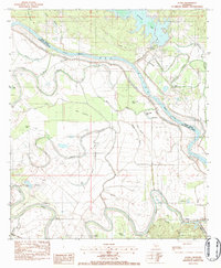 1983 Aloha1984 Print · USGSNatchitoches and Grant Parishes meet along the winding Red River in the early eighties, where bayous and oil fields define the local economy. Researchers can trace family roots at Marco Cem or locate old sites like St Simons Ch and the Aloha Oil Field.2 unique versions available
 - 1986 Map of Winnfield
 1986 Winnfield1986 Print · USGSCentral Louisiana in the mid-1980s was a landscape of timber towns and rail junctions woven through the Kisatchie National Forest. Researchers can trace the legacy of the lumber and rail eras through settlements like Good Pine, Packton, and Zenoria.2 unique versions available
End of results
Showing maps 1-2 of 2
Top cities near Aloha
- Alexandria historical maps
- Colfax historical maps
- Boyce historical maps
- Montgomery historical maps
- Atlanta historical maps
Frequently asked questions
- What are the different types of historical maps available for Aloha?
- What is the oldest map of Aloha?
- Where can I purchase historical maps of Aloha for my home or office?
- Where can I download high-res historical maps of Aloha?
- Are there historical topographic maps available for Aloha?
- Is there historical aerial imagery available for Aloha?
- Where are historical maps of Aloha sourced from?