1930s Maps of Faircloth, Louisiana
Explore 2 historic maps of Faircloth from the 1930s. These maps offer a rare glimpse into what life looked like during the 1930s — showing old roads, neighborhoods, homes, and landmarks that have changed or disappeared over time.
Whether you're researching your family's past, planning a metal detecting trip, or studying how Faircloth's landscape evolved across the 1930s, these high-resolution maps are a powerful tool for exploring the history of this region.
- Focus on a specific era: All maps on this page are from the 1930s, giving you a focused view of this time period.
- See what’s changed: Compare century-old streets, trails, and buildings to today's modern landscape using overlays and satellite layers.
- Research with precision: Use these maps for genealogy, historical research, land use analysis, or educational projects.
- View, download, or print: Maps are fully viewable online in high resolution, and can be downloaded or printed for your own records.
Start exploring Faircloth's history through authentic maps from the 1930s. This is your window into the past.
Faircloth, LA maps
(2)- 1932 Map of Colfax SE
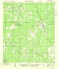 1932 Colfax SE1932 Print · USGSGrant Parish in the early thirties shows a rural landscape defined by the nascent Kisatchie National Forest and local timber corridors. Researchers can locate community landmarks such as Faircloth, Dry Prong, and rural schoolhouses like Black Cr Sch.
 - 1936 Map of Colfax
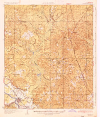 1936 Colfax1936 Print · USGSGrant Parish in the mid-1930s is defined by the sweeping course of the Red River and the expanding reaches of Lake Iatt. Local researchers can trace old family sites and rural institutions like Parsons Cem, Summerfield, and the Oak Grove Sch.2 unique versions available
End of results
Showing maps 1-2 of 2
Top cities near Faircloth
- Pineville historical maps
- Ball historical maps
- Colfax historical maps
- Boyce historical maps
- Dry Prong historical maps
- Pollock historical maps
See more
Frequently asked questions
- What are the different types of historical maps available for Faircloth?
- What is the oldest map of Faircloth?
- Where can I purchase historical maps of Faircloth for my home or office?
- Where can I download high-res historical maps of Faircloth?
- Are there historical topographic maps available for Faircloth?
- Is there historical aerial imagery available for Faircloth?
- Where are historical maps of Faircloth sourced from?