1940s Maps of Pollock, Louisiana
Explore 2 historic maps of Pollock from the 1940s. These maps offer a rare glimpse into what life looked like during the 1940s — showing old roads, neighborhoods, homes, and landmarks that have changed or disappeared over time.
Whether you're researching your family's past, planning a metal detecting trip, or studying how Pollock's landscape evolved across the 1940s, these high-resolution maps are a powerful tool for exploring the history of this region.
- Focus on a specific era: All maps on this page are from the 1940s, giving you a focused view of this time period.
- See what’s changed: Compare century-old streets, trails, and buildings to today's modern landscape using overlays and satellite layers.
- Research with precision: Use these maps for genealogy, historical research, land use analysis, or educational projects.
- View, download, or print: Maps are fully viewable online in high resolution, and can be downloaded or printed for your own records.
Start exploring Pollock's history through authentic maps from the 1940s. This is your window into the past.
Pollock, LA maps
(2)- 1941 Map of Alexandria, 1944 Print
 1941 Alexandria1944 Print · USGSRapides and Grant Parishes are captured here in the early 1940s as massive military training grounds expanded alongside established rail towns. Trace the footprints of Camp Livingston and Camp Beauregard or locate local landmarks like the Philadelphia Ch and Kolin.
 - 1941 Map of Pollock, 1944 Print
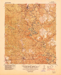 1941 Pollock1944 Print · USGSGrant and La Salle Parishes are defined by the winding oxbows of the Little River and a thriving rail-and-timber network in the early 1940s. Genealogists can trace family roots at Pinebluff Cem, Hawthorne Cem, or the small settlement at Antonia.2 unique versions available
End of results
Showing maps 1-2 of 2
Top cities near Pollock
Frequently asked questions
- What are the different types of historical maps available for Pollock?
- What is the oldest map of Pollock?
- Where can I purchase historical maps of Pollock for my home or office?
- Where can I download high-res historical maps of Pollock?
- Are there historical topographic maps available for Pollock?
- Is there historical aerial imagery available for Pollock?
- Where are historical maps of Pollock sourced from?