1900s (20th Century) Maps of Marce, Louisiana
Explore 9 historic maps of Marce from the 1900s (20th Century). These maps offer a rare glimpse into what life looked like during the 1900s — showing old roads, neighborhoods, homes, and landmarks that have changed or disappeared over time.
Whether you're researching your family's past, planning a metal detecting trip, or studying how Marce's landscape evolved across the 1900s, these high-resolution maps are a powerful tool for exploring the history of this region.
- Focus on a specific era: All maps on this page are from the 1900s, giving you a focused view of this time period.
- See what’s changed: Compare century-old streets, trails, and buildings to today's modern landscape using overlays and satellite layers.
- Research with precision: Use these maps for genealogy, historical research, land use analysis, or educational projects.
- View, download, or print: Maps are fully viewable online in high resolution, and can be downloaded or printed for your own records.
Start exploring Marce's history through authentic maps from the 1900s. This is your window into the past.
Marce, LA maps
(9)- 1937 Map of Derouen, 1963 Print
 1937 Derouen1963 Print · USGSCoastal Louisiana in the late 1930s is revealed here as a landscape of salt domes and sugarcane plantations linked by rail and marsh. Genealogists and historians can trace family locations through Duboin Plantation, St Helens Church, and the settlement of Delcambre.
 - 1945 Map of New Orleans
 1945 New Orleans1945 Print · USGSCoastal Louisiana and the Mississippi delta are captured here just after the war, showing the region's transition into a modern industrial and transit hub. Genealogists can trace family settlements along Bayou Teche or identify rail stops for the Illinois Central and Texas & Pacific lines.
 - 1963 Map of New Orleans
 1963 New Orleans1963 Print · USGSCoastal Louisiana in the mid-twentieth century reveals a complex world of bayou settlements, expanding oil fields, and vital rail networks. Genealogists and historians can trace family roots through river towns like Thibodaux or follow the Southern Pacific line through Franklin and Patterson.4 unique versions available
 - 1963 Map of Delcambre, 1964 Print
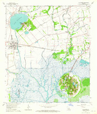 1963 Delcambre1964 Print · USGSCoastal Louisiana marshes and unique salt dome topography are showcased here during the mid-century. Genealogists and historians can trace rail-side settlements like Broussville and explore the detailed grounds of Avery Island and Jungle Gardens.2 unique versions available
 - 1963 Map of Derouen, 1968 Print
 1963 Derouen1968 Print · USGSCoastal Iberia Parish comes into focus during the early 1960s, showing the intersection of salt dome industry and traditional bayou life. Genealogists and researchers can trace family lands near Duboin Plantation, New Iberia, and the historic St Joseph Cem.
 - 1966 Map of Derouen
 1966 Derouen1966 Print · USGSThe coastal marshlands and industrial salt domes of South Louisiana are captured here in the mid-1960s. Genealogists and local historians can trace family-named sites like Broussville and Migues, or explore industrial landmarks at Avery Island and the Port of New Iberia.
 - 1966 Map of New Orleans
 1966 New Orleans1966 Print · USGSCoastal Louisiana in the mid-1960s reveals a transition from traditional bayou life to an intensive offshore oil and gas economy. Researchers can trace the rail lines of the Southern Pacific RR through Morgan City or locate the Eugene Island Lighthouse among the delta's shifting marshes.
 - 1983 Map of Morgan City
 1983 Morgan City1983 Print · USGSThe Louisiana coast in the early eighties reveals a landscape shaped by water and industry, from the salt domes to the sugar parishes. Trace the historic corridor of the Bayou Teche, the rail lines through Morgan City, and the wetlands of Weeks Island.2 unique versions available
 - 1994 Map of Delcambre, 1998 Print
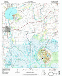 1994 Delcambre1998 Print · USGSThe salt domes and marshes of Iberia and Vermilion parishes are captured here in the mid-nineties, showing a landscape defined by industrial canals and coastal wetlands. Researchers can locate family landmarks like Miguel Cem, the heights of Avery Island, and settlements such as Bob Acres and Broussville.
End of results
Showing maps 1-9 of 9
Top cities near Marce
- Lafayette historical maps
- New Iberia historical maps
- Abbeville historical maps
- Jeanerette historical maps
- Youngsville historical maps
- Erath historical maps
See more
Frequently asked questions
- What are the different types of historical maps available for Marce?
- What is the oldest map of Marce?
- Where can I purchase historical maps of Marce for my home or office?
- Where can I download high-res historical maps of Marce?
- Are there historical topographic maps available for Marce?
- Is there historical aerial imagery available for Marce?
- Where are historical maps of Marce sourced from?