1970s Maps of Iberville Parish, Louisiana
Explore 6 historic maps of Iberville Parish from the 1970s. These maps offer a rare glimpse into what life looked like during the 1970s — showing old roads, neighborhoods, homes, and landmarks that have changed or disappeared over time.
Whether you're researching your family's past, planning a metal detecting trip, or studying how Iberville Parish's landscape evolved across the 1970s, these high-resolution maps are a powerful tool for exploring the history of this region.
- Focus on a specific era: All maps on this page are from the 1970s, giving you a focused view of this time period.
- See what’s changed: Compare century-old streets, trails, and buildings to today's modern landscape using overlays and satellite layers.
- Research with precision: Use these maps for genealogy, historical research, land use analysis, or educational projects.
- View, download, or print: Maps are fully viewable online in high resolution, and can be downloaded or printed for your own records.
Start exploring Iberville Parish's history through authentic maps from the 1970s. This is your window into the past.
Iberville Parish, LA maps
(6)- 1970 Map of Lake Chicot, 1972 Print
 1970 Lake Chicot1972 Print · USGSThe Atchafalaya swamp in the early seventies shows a landscape defined by its shifting waterways and the mid-century energy boom. Trace the intricate network of Keelboat Pass, Deadman Bayou, and the Oil and Gas Field to understand the local economy and geography.2 unique versions available
 - 1973 Map of Lake Mongoulois, 1976 Print
 1973 Lake Mongoulois1976 Print · USGSThe Atchafalaya swamp in the early seventies reveals a landscape defined by water management and resource extraction. Genealogists and historians can trace the small settlement of Doris and an old Cem amidst a network of oil wells and the waters of Lake Mongoulois.
 - 1974 Map of Belle Rose, 1975 Print
 1974 Belle Rose1975 Print · USGSAssumption and Ascension Parishes come alive in the mid-seventies, showing the distinctive long-lot patterns along the Mississippi River and Bayou Lafourche. Genealogists and local historians can trace family-named settlements like Smoke Bend, Belle Alliance, and Klotzville as they appeared decades ago.
 - 1974 Map of White Castle, 1975 Print
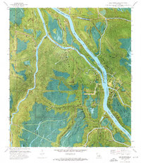
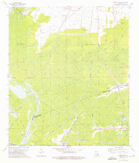
 1974 White Castle1975 Print · USGSIberville Parish is captured in the mid-1970s as a bustling corridor of river commerce and agriculture along the Mississippi. Researchers can trace historic settlements like Tally Ho and Samstown, or locate landmarks like the National Leprosarium and Madonna Chapel.2 unique versions available
 - 1974 Map of Lone Star, 1975 Print
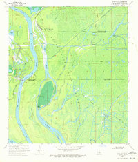
 1974 Lone Star1975 Print · USGSThe Atchafalaya Basin swamplands are captured here in the mid-1970s, showing a landscape where heavy industry and delta hydrology meet. Researchers can trace the layout of the Napoleonville Oil and Gas Field and old settlements like Pierre Part and Lone Star.3 unique versions available
 - 1974 Map of Carville, 1975 Print
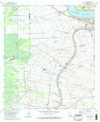
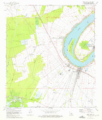
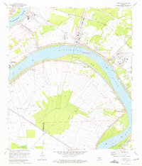 1974 Carville1975 Print · USGSThe Mississippi River meanders through the plantation and industrial corridor of Iberville and Ascension parishes during the mid-seventies. Trace local history at the National Leprosarium and old river landings like Hohen Solms and Philadelphia Point.2 unique versions available
End of results
Showing maps 1-6 of 6
Top cities of Iberville Parish
- Plaquemine historical maps
- White Castle historical maps
- Maringouin historical maps
- Rosedale historical maps
- Grosse Tete historical maps
Frequently asked questions
- What are the different types of historical maps available for Iberville Parish?
- What is the oldest map of Iberville Parish?
- Where can I purchase historical maps of Iberville Parish for my home or office?
- Where can I download high-res historical maps of Iberville Parish?
- Are there historical topographic maps available for Iberville Parish?
- Is there historical aerial imagery available for Iberville Parish?
- Where are historical maps of Iberville Parish sourced from?