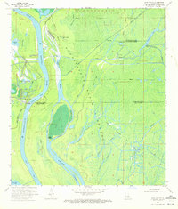
1970 Map of Lake Chicot
USGS Topo · Published 1972About this map
The Atchafalaya Basin Floodway dominates this 1970 landscape, where the labyrinthine waterways of the Louisiana swamp meet mid-century industrial extraction. This survey documents a complex hydrologic network of passes and bayous, including the Main Channel and the winding Pigeon Bayou, which served as critical arteries for both natural drainage and local navigation. The era's focus on energy is evident through the extensive Oil and Gas Field and numerous drill holes scattered across the wetlands. Notable landmarks like Hog Island and Turkey Island sit at the confluence of the Atchafalaya River and Chicot Lake, illustrating the fluid nature of the basin before further modern engineering. For genealogists and local historians, the boundary lines of Iberville, St. Martin, and Iberia Parishes provide essential geographic context for family land and resource history.
Find a feature on this map
37 named features on this map. Tap any name to fly to it.
Don’t see what you’re looking for? This feature index may not catch every label — zoom into the map to look around manually.
Map Details
Editions of this 1970 Lake Chicot Map
2 editions found
Other maps of this area

1935 · Chicot Lake
USGS Topo · 1:62,500

1937 · Jeanerette
USGS Topo · 1:62,500

1941 · Loreauville
USGS Topo · 1:62,500

1945 · New Orleans
USGS Topo · 1:250,000

1948 · Foster
USGS Topo · 1:62,500

1953 · Crescent
USGS Topo · 1:24,000

1953 · Pigeon Bay
USGS Topo · 1:24,000

1954 · Chicot Lake
USGS Topo · 1:62,500

1954 · Loreauville
USGS Topo · 1:62,500

1954 · Jeanerette
USGS Topo · 1:62,500