1990s Maps of Ramah, Louisiana
Explore 2 historic maps of Ramah from the 1990s. These maps offer a rare glimpse into what life looked like during the 1990s — showing old roads, neighborhoods, homes, and landmarks that have changed or disappeared over time.
Whether you're researching your family's past, planning a metal detecting trip, or studying how Ramah's landscape evolved across the 1990s, these high-resolution maps are a powerful tool for exploring the history of this region.
- Focus on a specific era: All maps on this page are from the 1990s, giving you a focused view of this time period.
- See what’s changed: Compare century-old streets, trails, and buildings to today's modern landscape using overlays and satellite layers.
- Research with precision: Use these maps for genealogy, historical research, land use analysis, or educational projects.
- View, download, or print: Maps are fully viewable online in high resolution, and can be downloaded or printed for your own records.
Start exploring Ramah's history through authentic maps from the 1990s. This is your window into the past.
Ramah, LA maps
(2)- 1992 Map of Maringouin
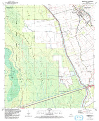 1992 Maringouin1992 Print · USGSThe Atchafalaya Basin in the early nineties reveals a landscape split between the wild Atchafalaya National Wildlife Refuge and the industrial bayou towns. Researchers can trace family roots at New Zion Ch or explore the geography of the Maringouin Oil Field and the old Union Pacific line.
 - 1999 Map of Maringouin, 2001 Print
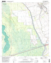 1999 Maringouin2001 Print · USGSIberville and Pointe Coupee parishes at the close of the century show a landscape defined by the Atchafalaya Basin Floodway and river commerce. Researchers can trace family sites at Shiloh Ch and West Oak Lane Cem or follow the UNION PACIFIC rail line through Musson.2 unique versions available
End of results
Showing maps 1-2 of 2
Top cities near Ramah
- Addis historical maps
- Livonia historical maps
- Fordoche historical maps
- Maringouin historical maps
- Rosedale historical maps
- Grosse Tete historical maps
Frequently asked questions
- What are the different types of historical maps available for Ramah?
- What is the oldest map of Ramah?
- Where can I purchase historical maps of Ramah for my home or office?
- Where can I download high-res historical maps of Ramah?
- Are there historical topographic maps available for Ramah?
- Is there historical aerial imagery available for Ramah?
- Where are historical maps of Ramah sourced from?