Old Maps of Jefferson Davis Parish, Louisiana for Academic Research
Study the evolution of Jefferson Davis Parish with 161 high-resolution historic maps. Whether you're teaching, researching, or modeling changes in land use, these maps provide essential visual documentation of urban, environmental, and geographic change.
- Analyze long-term change: Track patterns in development, transportation, and natural features.
- Ideal for environmental or urban studies: Support academic projects with primary historical map data.
- Use in the classroom or lab: Educators and researchers rely on these maps to bring historical context to life.
These maps are a powerful tool for teaching, research, and visualizing how Jefferson Davis Parish has changed over the decades.
Jefferson Davis Parish, LA maps
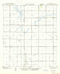
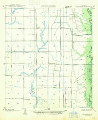
(161)- 1935 Map of Gaytine
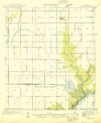
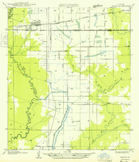
 1935 Gaytine1935 Print · USGSSouthwestern Louisiana's wetlands and timber country are captured here in the mid-1930s as the logging era left its mark on the landscape. Researchers can trace old industrial footprints through the Old Logging Railroad Grade and find small communities like Gaytine and Turps.
 - 1946 Map of Lacassine
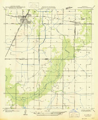
 1946 Lacassine1946 Print · USGSSouthwestern Louisiana’s prairie and marshland are captured here in the mid-1940s as the rail and canal systems shaped local industry. Family historians can trace the area around Lacassine and Verrett, identifying landmarks like St Joseph Ch and Yount Lee Siding.
 - 1946 Map of Lake Arthur
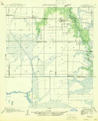
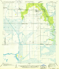
 1946 Lake Arthur1946 Print · USGSLake Arthur and its surrounding marshlands are shown here in the mid-forties during a period of steady coastal development. Researchers can trace family sites near St Theresa Ch, locate the Andress Gate Cem, or follow the path of the Southern Pacific railroad.
 - 1946 Map of Hayes
 1946 Hayes1946 Print · USGSCoastal prairie and marshlands meet along the Calcasieu-Jefferson Davis Parish line just after the war. Local researchers can trace the intricate network of the Morgan Canal, the Southern Pacific rail line, and the location of the Hayes Sch.
 - 1946 Map of Mermentau
 1946 Mermentau1946 Print · USGSAcadia Parish in the mid-1940s centers on the critical rail and water junction at the Mermentau river crossing. Genealogists and local historians can trace family locations near Quibodeau Cem, the Sand Mill, and the rail stops at Midland or Egan.
 - 1946 Map of Jennings
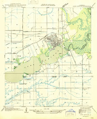
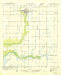
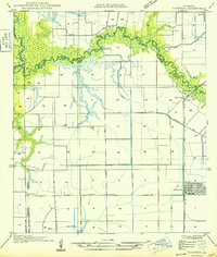
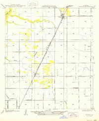
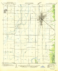 1946 Jennings1946 Print · USGSJefferson Davis Parish is documented here shortly after the war, showing the well-defined street layouts of Jennings and Roanoke. Genealogists and historians can trace property lines alongside the Southern Pacific railroad or follow the essential drainage of Sturdivant Canal.
 - 1947 Map of Gaytine
 1947 Gaytine1947 Print · USGSLouisiana's bayou country is captured in the mid-1930s as the timber and rail era left its mark across Beauregard Parish. Researchers can trace the path of the Southern Pacific and the Old Logging Railroad Grade near Gaytine and Turps.
 - 1947 Map of Evangeline
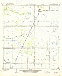
 1947 Evangeline1947 Print · USGSAcadia Parish and the Jefferson Davis Parish border are captured mid-century during a period of massive agricultural irrigation development. Genealogists and historians can trace family locations near Evangeline, St Josephs Ch, and the Riverside Cem.
 - 1947 Map of Kinder
 1947 Kinder1947 Print · USGSThe rail junction at Kinder during the mid-1930s serves as the heart of this survey of the Allen and Jefferson Davis parish line. Genealogists and researchers can trace local settlements and rail sidings like Rodgerville, Lauderdale, and Coverdale Sta.
 - 1947 Map of Fenton
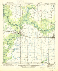
 1947 Fenton1947 Print · USGSMid-century Jefferson Davis Parish comes alive along the Missouri Pacific rail line and U.S. Highway 165 during this post-war period. Genealogists and local historians can trace the foundations of Fenton, find the Rose Hill School, and locate the Woodlawn Cem near the parish line.
 - 1947 Map of Thornwell
 1947 Thornwell1947 Print · USGSAgricultural drainage and rail transport define this coastal Louisiana landscape in the 1930s. Researchers can trace the Southern Pacific line through Thornwell, find the Lowry Sch, and map old irrigation routes like the Live Oak Farm Irrigation Canal.
 - 1947 Map of Hecker
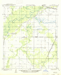
 1947 Hecker1947 Print · USGSCalcasieu Parish was undergoing a significant transition between the world wars as timber harvesting and irrigation-based farming shaped the land. Researchers can trace the path of the Logging Railroad and locate family homes near Hecker and Stackpole.
 - 1947 Map of Pine Island
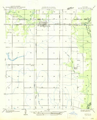
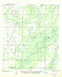
 1947 Pine Island1947 Print · USGSJefferson Davis Parish in the mid-1940s is defined here by its rural schools and early aviation history. Genealogists and local historians can trace the area around Pine Island and find the location of the Meadow Prairie Sch or the Emergency Landing Field.
 - 1947 Map of Welsh
 1947 Welsh1947 Print · USGSCoastal prairie life in Jefferson Davis Parish is captured here during a period of agricultural expansion and infrastructure building. Genealogists and local historians can trace the early layout of Welsh, the rural Niblett Sch, and the essential water systems of the Welsh Canal.
 - 1947 Map of Elton
 1947 Elton1947 Print · USGSJefferson Davis Parish was a landscape of rail-dependent farming communities in the late 1940s. Genealogists and local historians can locate rural landmarks such as China Cem, Fusilier Sch, and the small settlement of Wilburton.
 - 1947 Map of Edna
 1947 Edna1947 Print · USGSSouthwest Louisiana in the mid-1930s is a landscape of shifting bayous and expanding rail lines. Genealogists and historians can trace the early footprints of Indian Village, the community of Edna, and remnants of the Old Logging Railroad Grade.
 - 1947 Map of Hathaway
 1947 Hathaway1947 Print · USGSJefferson Davis Parish in the late 1940s reveals a specialized landscape of rice farming and rural crossroads. Genealogists and researchers can trace old school sites like Grand Marais Sch and the community layouts of Hathaway and Raymond.
 - 1947 Map of Thompson Bluff
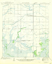
 1947 Thompson Bluff1947 Print · USGSSouthwestern Louisiana's timber and river country is captured here during the late 1930s and 1940s. Researchers can trace the winding Calcasieu River and locate historic rural landmarks like Barnes Creek Ch and the Thompson Sch.
 - 1947 Map of Basile
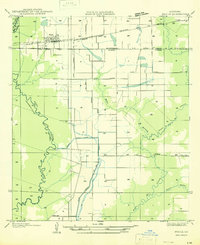 1947 Basile1947 Print · USGSBasile and the surrounding Louisiana prairie are captured here in the late 1940s as the region's agricultural and rail networks were fully established. Researchers can trace family sites near Reed Cem and St Monica Ch, or follow the industrial waterworks of the Mamou Canal.
 - 1949 Map of Gueydan
 1949 Gueydan1949 Print · USGSThe coastal prairies of Vermilion Parish meet the bayous of Acadia in the late 1940s. Genealogists can locate the Legia Cem and trace the Southern Pacific rail line through Riceville and into the streets of Gueydan.
 - 1949 Map of Basile
 1949 Basile1949 Print · USGSLouisiana's prairie and bayou country meet in the late 1940s at the junction of four different parishes. Researchers can trace the family landmarks of this agricultural landscape, from the Reed Cem and St Monica Ch to the remote Kaplan Pump Sta.
 - 1949 Map of Hayes
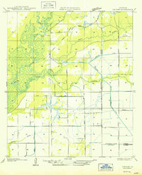
 1949 Hayes1949 Print · USGSCalcasieu and Jefferson Davis Parishes are shown during a period of agricultural expansion and marshland management in the late nineteen-forties. Researchers can trace the rail-and-water economy through features like the Southern Pacific line, the Hayes Sch, and the Illinois Plant.
 - 1950 Map of Fenton
 1950 Fenton1950 Print · USGSJefferson Davis Parish in the mid-twentieth century is shown here as a landscape of rail-side settlements and winding bayous. Genealogists can trace family footprints through rural sites like Rose Hill School, Woodlawn, and the Woodlawn Cem.
 - 1950 Map of Hecker
 1950 Hecker1950 Print · USGSSouthwestern Louisiana's wetlands and early agricultural infrastructure are visible here in the years following the mid-1930s field surveys. Trace the Old Logging Railroad Grade and the engineering of the Louisiana Irrigation Canal near Hecker.
 - 1952 Map of Lake Charles
 1952 Lake Charles1952 Print · USGSSouthwest Louisiana is captured here in the mid-fifties, showing a landscape defined by the rise of the petrochemical industry and deep-water navigation. Researchers can trace family roots through numerous small-town settlements and oil developments like Nibletts Bluff, the Lockport Oil Field, and Starks.
Showing maps 1-25 of 161
Top cities of Jefferson Davis Parish
- Jennings historical maps
- Welsh historical maps
- Lake Arthur historical maps
- Elton historical maps
- Roanoke historical maps
- Fenton historical maps
Frequently asked questions
- What are the different types of historical maps available for Jefferson Davis Parish?
- What is the oldest map of Jefferson Davis Parish?
- Where can I purchase historical maps of Jefferson Davis Parish for my home or office?
- Where can I download high-res historical maps of Jefferson Davis Parish?
- Are there historical topographic maps available for Jefferson Davis Parish?
- Is there historical aerial imagery available for Jefferson Davis Parish?
- Where are historical maps of Jefferson Davis Parish sourced from?