1940s Maps of Illinois Plant, Louisiana
Explore 2 historic maps of Illinois Plant from the 1940s. These maps offer a rare glimpse into what life looked like during the 1940s — showing old roads, neighborhoods, homes, and landmarks that have changed or disappeared over time.
Whether you're researching your family's past, planning a metal detecting trip, or studying how Illinois Plant's landscape evolved across the 1940s, these high-resolution maps are a powerful tool for exploring the history of this region.
- Focus on a specific era: All maps on this page are from the 1940s, giving you a focused view of this time period.
- See what’s changed: Compare century-old streets, trails, and buildings to today's modern landscape using overlays and satellite layers.
- Research with precision: Use these maps for genealogy, historical research, land use analysis, or educational projects.
- View, download, or print: Maps are fully viewable online in high resolution, and can be downloaded or printed for your own records.
Start exploring Illinois Plant's history through authentic maps from the 1940s. This is your window into the past.
Illinois Plant, LA maps
(2)- 1946 Map of Hayes
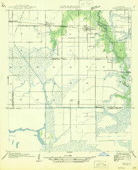 1946 Hayes1946 Print · USGSCoastal prairie and marshlands meet along the Calcasieu-Jefferson Davis Parish line just after the war. Local researchers can trace the intricate network of the Morgan Canal, the Southern Pacific rail line, and the location of the Hayes Sch.
 - 1949 Map of Hayes
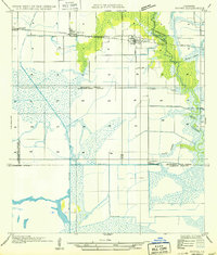 1949 Hayes1949 Print · USGSCalcasieu and Jefferson Davis Parishes are shown during a period of agricultural expansion and marshland management in the late nineteen-forties. Researchers can trace the rail-and-water economy through features like the Southern Pacific line, the Hayes Sch, and the Illinois Plant.
End of results
Showing maps 1-2 of 2
Top cities near Illinois Plant
- Lake Charles historical maps
- Welsh historical maps
- Lake Arthur historical maps
- Iowa historical maps
- Hayes historical maps
- Roanoke historical maps
Frequently asked questions
- What are the different types of historical maps available for Illinois Plant?
- What is the oldest map of Illinois Plant?
- Where can I purchase historical maps of Illinois Plant for my home or office?
- Where can I download high-res historical maps of Illinois Plant?
- Are there historical topographic maps available for Illinois Plant?
- Is there historical aerial imagery available for Illinois Plant?
- Where are historical maps of Illinois Plant sourced from?