1930s Maps of Westwego, Louisiana
Explore 3 historic maps of Westwego from the 1930s. These maps offer a rare glimpse into what life looked like during the 1930s — showing old roads, neighborhoods, homes, and landmarks that have changed or disappeared over time.
Whether you're researching your family's past, planning a metal detecting trip, or studying how Westwego's landscape evolved across the 1930s, these high-resolution maps are a powerful tool for exploring the history of this region.
- Focus on a specific era: All maps on this page are from the 1930s, giving you a focused view of this time period.
- See what’s changed: Compare century-old streets, trails, and buildings to today's modern landscape using overlays and satellite layers.
- Research with precision: Use these maps for genealogy, historical research, land use analysis, or educational projects.
- View, download, or print: Maps are fully viewable online in high resolution, and can be downloaded or printed for your own records.
Start exploring Westwego's history through authentic maps from the 1930s. This is your window into the past.
Westwego, LA maps
(3)- 1932 Map of New Orleans NW
 1932 New Orleans NW1932 Print · USGSJefferson Parish is caught in a moment of rapid transformation in the early thirties as New Orleans expands westward. Researchers can trace the rise of early suburbs like Bonnabel Place, the construction of the Huey P Long Bridge, and the location of the historic Wedell Williams Airport.
 - 1932 Map of New Orleans SW
 1932 New Orleans SW1932 Print · USGSCoastal Louisiana marshes near the Jefferson and St. Charles Parish line are captured in the early thirties as dredging and canals reshaped the delta. Researchers can trace the original courses of Bayou Segnette and Bayou Couba near Woods Place.
 - 1938 Map of New Orleans West
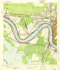 1938 New Orleans West1938 Print · USGSJefferson Parish emerges as a vital transportation hub during the mid-thirties, dominated by the massive river bend and the rise of suburban Metairie. Genealogists and historians can trace the early footprints of Bonnabel Place and Kenner, or locate the historic Deckbar Sch and the U S Marine Hospital.3 unique versions available
End of results
Showing maps 1-3 of 3
Top cities near Westwego
- New Orleans historical maps
- Metairie historical maps
- Kenner historical maps
- Algiers historical maps
- Chalmette historical maps
- Gretna historical maps
See more
Frequently asked questions
- What are the different types of historical maps available for Westwego?
- What is the oldest map of Westwego?
- Where can I purchase historical maps of Westwego for my home or office?
- Where can I download high-res historical maps of Westwego?
- Are there historical topographic maps available for Westwego?
- Is there historical aerial imagery available for Westwego?
- Where are historical maps of Westwego sourced from?