1950s Maps of Lafayette Parish, Louisiana
Explore 14 historic maps of Lafayette Parish from the 1950s. These maps offer a rare glimpse into what life looked like during the 1950s — showing old roads, neighborhoods, homes, and landmarks that have changed or disappeared over time.
Whether you're researching your family's past, planning a metal detecting trip, or studying how Lafayette Parish's landscape evolved across the 1950s, these high-resolution maps are a powerful tool for exploring the history of this region.
- Focus on a specific era: All maps on this page are from the 1950s, giving you a focused view of this time period.
- See what’s changed: Compare century-old streets, trails, and buildings to today's modern landscape using overlays and satellite layers.
- Research with precision: Use these maps for genealogy, historical research, land use analysis, or educational projects.
- View, download, or print: Maps are fully viewable online in high resolution, and can be downloaded or printed for your own records.
Start exploring Lafayette Parish's history through authentic maps from the 1950s. This is your window into the past.
Lafayette Parish, LA maps
(14)- 1952 Map of Lake Charles
 1952 Lake Charles1952 Print · USGSSouthwest Louisiana is captured here in the mid-fifties, showing a landscape defined by the rise of the petrochemical industry and deep-water navigation. Researchers can trace family roots through numerous small-town settlements and oil developments like Nibletts Bluff, the Lockport Oil Field, and Starks.
 - 1954 Map of Lafayette
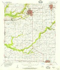
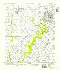 1954 Lafayette1954 Print · USGSMid-century Lafayette is captured here as the city grid expands toward the Louisiana Southwestern Institute and the Vermilion River. Genealogists can trace family tracts and small rail stops like Tolson, Scott, and Ely Junction.
 - 1954 Map of Duson
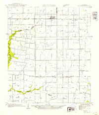 1954 Duson1954 Print · USGSDuson and the surrounding Acadiana prairie are captured here in the mid-1950s as a landscape of small settlements and irrigation networks. Researchers can trace local genealogy through landmarks like Indian Bayou High Sch, Kimbal Chapel, and the community of Indian.
 - 1954 Map of Leroy
 1954 Leroy1954 Print · USGSVermilion Parish in the mid-fifties is captured here as a landscape of irrigation canals and dispersed rural settlements. Family historians can locate family-named burial sites like Abshire Cem and small communities such as Leroy, Andrew, and Meaux.
 - 1954 Map of Rayne
 1954 Rayne1954 Print · USGSAcadia Parish in the mid-fifties is captured here as a landscape of productive prairie and vital rail corridors. Genealogists and local historians can trace the rural layout of Ebenezer Sch and Hebron Ch, or follow the winding Bayou Queue de Tortue as it meanders past Faulk Bridge.
 - 1954 Map of Milton
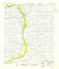 1954 Milton1954 Print · USGSLafayette and Vermilion Parish life in the 1950s is defined by the winding Vermilion River and the rural rail economy. Genealogists and local historians can trace the locations of Le Blanc Sch, the Southern Pacific line, and early tracks in Milton.
 - 1954 Map of Lake Charles, 1964 Print
 1954 Lake Charles1964 Print · USGSSouthwest Louisiana in the mid-fifties is defined by its massive petroleum industry and its complex network of bayous and rail lines. Researchers can trace the development of the Sulphur Mines Oil Field or locate historic settlements like Longville and De Quincy.3 unique versions available
 - 1954 Map of Baton Rouge, 1974 Print
 1954 Baton Rouge1974 Print · USGSSoutheast Louisiana in the mid-fifties is captured here during a period of transition for its river and rail economies. Researchers can trace the path of the Mississippi River and find landmarks like the Bonnet Carre Spillway and Bayou Plaquemine.2 unique versions available
 - 1955 Map of Crowley, 1956 Print
 1955 Crowley1956 Print · USGSAcadia Parish and the northern edge of Vermilion Parish are shown in the mid-fifties, during a period of agricultural and industrial expansion. Researchers can trace family history through numerous rural landmarks like Hebron Ch, Woodlawn Cem, and Simon Cem.4 unique versions available
 - 1955 Map of Lafayette, 1956 Print
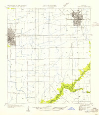
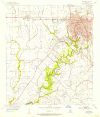 1955 Lafayette1956 Print · USGSLafayette and the surrounding Acadiana prairies are captured in the mid-fifties, showing a bustling regional center defined by the Southern Pacific and SW Louisiana Institute. Genealogists can trace family names through numerous burial sites like Whittington Cem and Broussard Cem.3 unique versions available
 - 1955 Map of Lafayette, 1956 Print
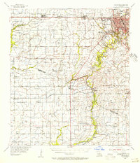 1955 Lafayette1956 Print · USGSMid-century Acadiana is captured here as LAFAYETTE expands near traditional settlements like Youngsville and Maurice. Genealogists and historians can locate numerous family-named landmarks, such as Abshire Cem, Judice High Sch, and the Duson Gas Field.5 unique versions available
 - 1956 Map of Baton Rouge
 1956 Baton Rouge1956 Print · USGSSouth Louisiana at the height of the mid-century oil boom shows a landscape of river oxbows and rising industry. Researchers can trace family roots through river towns like Scotlandville or locate early industrial sites and Oil wells near Lake Maurepas.
 - 1957 Map of St. Martinville, 1958 Print
 1957 St. Martinville1958 Print · USGSSt. Martin and Iberia Parishes are captured here during the mid-fifties, showing the intersection of traditional plantation culture and new military and industrial growth. Genealogists and local historians can trace family lands near Romero Plantation, find old country schools like Forgey Sch, or locate the US Naval Auxiliary Air Station.2 unique versions available
 - 1957 Map of Carencro, 1958 Print
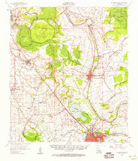
 1957 Carencro1958 Print · USGSMid-century south Louisiana comes alive in this survey of the prairies and bayous of Acadia and St. Landry Parishes. Genealogists and historians can trace family locations near Church Point, Grand Coteau, and Vatican, or find rural landmarks like Sacred Heart Academy and Mt Calvary Cem.2 unique versions available
End of results
Showing maps 1-14 of 14
Top cities of Lafayette Parish
Frequently asked questions
- What are the different types of historical maps available for Lafayette Parish?
- What is the oldest map of Lafayette Parish?
- Where can I purchase historical maps of Lafayette Parish for my home or office?
- Where can I download high-res historical maps of Lafayette Parish?
- Are there historical topographic maps available for Lafayette Parish?
- Is there historical aerial imagery available for Lafayette Parish?
- Where are historical maps of Lafayette Parish sourced from?