1990s Maps of Lafayette Parish, Louisiana
Explore 10 historic maps of Lafayette Parish from the 1990s. These maps offer a rare glimpse into what life looked like during the 1990s — showing old roads, neighborhoods, homes, and landmarks that have changed or disappeared over time.
Whether you're researching your family's past, planning a metal detecting trip, or studying how Lafayette Parish's landscape evolved across the 1990s, these high-resolution maps are a powerful tool for exploring the history of this region.
- Focus on a specific era: All maps on this page are from the 1990s, giving you a focused view of this time period.
- See what’s changed: Compare century-old streets, trails, and buildings to today's modern landscape using overlays and satellite layers.
- Research with precision: Use these maps for genealogy, historical research, land use analysis, or educational projects.
- View, download, or print: Maps are fully viewable online in high resolution, and can be downloaded or printed for your own records.
Start exploring Lafayette Parish's history through authentic maps from the 1990s. This is your window into the past.
Lafayette Parish, LA maps
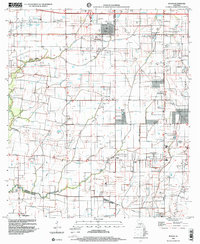
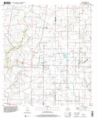
(10)- 1994 Map of Milton, 1998 Print
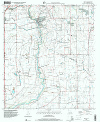
 1994 Milton1998 Print · USGSLafayette and Vermilion Parishes are shown in the mid-nineties during a period of residential expansion along the Vermilion River. Researchers can trace family history at Picard Cem or Gallet Cem and locate historic community hubs in Milton, Maurice, and Charon.
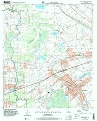
 - 1994 Map of Lafayette, 1998 Print
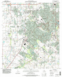 1994 Lafayette1998 Print · USGSLafayette and the surrounding Acadiana region are captured in the mid-1990s as suburban growth began to reshape the old parish lines. Genealogists can trace local history through several family-named landmarks including Cobb Cem, Broussard Cem, and the settlement of Scott.
 - 1998 Map of Crowley East, 2000 Print
 1998 Crowley East2000 Print · USGSAcadia Parish in the late 1990s displays a landscape of growing towns and established rural traditions. Genealogists can trace family footprints across Woodlawn Cem, Leger Cem, and parish schools like Redemptorist Sch or South Sch.
 - 1998 Map of Milton, 2000 Print
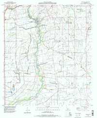
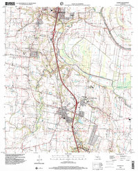
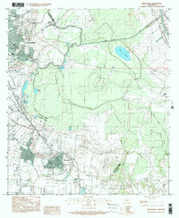
 1998 Milton2000 Print · USGSLafayette and Vermilion Parishes are shown at the turn of the millennium, shaped by the winding Vermilion River and a dense network of coulees. Genealogists and local historians can trace family ties at Picard Cem and Bodoin Cem or locate the early centers of Milton and Maurice.
 - 1998 Map of Duson, 2000 Print
 1998 Duson2000 Print · USGSLafayette Parish and Acadia Parish are shown in the late 1990s, revealing a landscape of prairie bayous and agricultural development. Researchers can locate family landmarks such as Antlers Cem, Morning Star Ch, and the community of Sadou.
 - 1998 Map of Breaux Bridge, 2000 Print
 1998 Breaux Bridge2000 Print · USGSBreaux Bridge and the surrounding Cajun heartland appear in the late nineties as a landscape defined by its historic bayous and oil industry. Researchers can trace family sites at St Bernard Cem or explore the old transport routes of the Old Railroad Grade and Bayou Teche.
 - 1998 Map of Sunset, 2001 Print
 1998 Sunset2001 Print · USGSSunset and Grand Coteau are captured at the end of the twentieth century, showcasing a landscape of historic academies and rural family cemeteries. Genealogists can trace local roots through Bellevue Memorial Park, St Charles College, and the settlement at Shuteston.
 - 1998 Map of Carencro, 2002 Print
 1998 Carencro2002 Print · USGSThe prairies north of Lafayette were undergoing a major transition at the end of the century as energy fields and suburbs expanded. Researchers can trace local history through the Ossun Sch, several cemeteries, and the sprawling Vatican Oil and Gas Field.
 - 1998 Map of Mire, 2002 Print
 1998 Mire2002 Print · USGSAcadia Parish at the turn of the millennium shows a rural landscape deeply integrated with the energy industry. Researchers can trace family homesteads near Higginbotham and Bristol or locate landmarks like Sunrise Ch and the Bosco Oil and Gas Field.
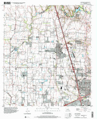
 - 1999 Map of Broussard, 2000 Print
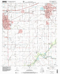
 1999 Broussard2000 Print · USGSThe Acadiana region at the close of the century shows the steady expansion of Lafayette toward the parish line. Researchers can trace local landmarks like the Holy Rosary Institute and settlements at Broussard, Billeaud, and Pilette.
End of results
Showing maps 1-10 of 10
Top cities of Lafayette Parish
Frequently asked questions
- What are the different types of historical maps available for Lafayette Parish?
- What is the oldest map of Lafayette Parish?
- Where can I purchase historical maps of Lafayette Parish for my home or office?
- Where can I download high-res historical maps of Lafayette Parish?
- Are there historical topographic maps available for Lafayette Parish?
- Is there historical aerial imagery available for Lafayette Parish?
- Where are historical maps of Lafayette Parish sourced from?