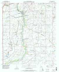
1994 Map of Milton
USGS Topo · Published 1998About this map
The Vermilion River serves as the central artery for this mid-1990s landscape, tracing the jagged boundary between Lafayette Parish and Vermilion Parish. This region is defined by a dense network of coulees and drainage ditches that manage the low-lying terrain, including Coulee Anselm, Coulee Darby, and Valcourt Coulee. The settlement pattern shows established towns like Milton, Maurice, and Youngsville beginning to expand, with newer developments like New Flanders appearing on the periphery. Genealogists will find significant local value in the scattered family burial grounds, such as Picard Cem, Bodoin Cem, and Gallet Cem. The infrastructure of the era is evident through the widespread sewage disposal ponds and utility features like the Substa and Comm Tower, reflecting the transition from traditional agrarian land use to modern residential and utility-focused development near the Bayou Parc Perdu.
Find a feature on this map
24 named features on this map. Tap any name to fly to it.
Don’t see what you’re looking for? This feature index may not catch every label — zoom into the map to look around manually.
Map Details
Editions of this 1994 Milton Map
This is the sole edition of this map. No revisions or reprints were ever made.
Other maps of this area

1932 · Abbeville NE
USGS Topo · 1:31,680

1932 · Abbeville NW
USGS Topo · 1:31,680

1934 · Duson
USGS Topo · 1:31,680

1937 · Derouen
USGS Topo · 1:62,500

1939 · St. Martinsville
USGS Topo · 1:62,500

1945 · New Orleans
USGS Topo · 1:250,000

1946 · Milton
USGS Topo · 1:31,680

1946 · Leroy
USGS Topo · 1:31,680

1946 · Lafayette
USGS Topo · 1:31,680

1952 · Lake Charles
USGS Topo · 1:250,000