1990s Maps of Flanders, Louisiana
Explore 2 historic maps of Flanders from the 1990s. These maps offer a rare glimpse into what life looked like during the 1990s — showing old roads, neighborhoods, homes, and landmarks that have changed or disappeared over time.
Whether you're researching your family's past, planning a metal detecting trip, or studying how Flanders's landscape evolved across the 1990s, these high-resolution maps are a powerful tool for exploring the history of this region.
- Focus on a specific era: All maps on this page are from the 1990s, giving you a focused view of this time period.
- See what’s changed: Compare century-old streets, trails, and buildings to today's modern landscape using overlays and satellite layers.
- Research with precision: Use these maps for genealogy, historical research, land use analysis, or educational projects.
- View, download, or print: Maps are fully viewable online in high resolution, and can be downloaded or printed for your own records.
Start exploring Flanders's history through authentic maps from the 1990s. This is your window into the past.
Flanders, LA maps
(2)- 1994 Map of Milton, 1998 Print
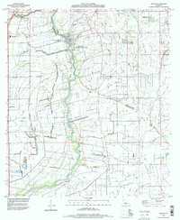 1994 Milton1998 Print · USGSLafayette and Vermilion Parishes are shown in the mid-nineties during a period of residential expansion along the Vermilion River. Researchers can trace family history at Picard Cem or Gallet Cem and locate historic community hubs in Milton, Maurice, and Charon.
 - 1998 Map of Milton, 2000 Print
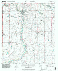 1998 Milton2000 Print · USGSLafayette and Vermilion Parishes are shown at the turn of the millennium, shaped by the winding Vermilion River and a dense network of coulees. Genealogists and local historians can trace family ties at Picard Cem and Bodoin Cem or locate the early centers of Milton and Maurice.
End of results
Showing maps 1-2 of 2
Top cities near Flanders
- Lafayette historical maps
- New Iberia historical maps
- Abbeville historical maps
- Rayne historical maps
- Scott historical maps
- Breaux Bridge historical maps
See more
Frequently asked questions
- What are the different types of historical maps available for Flanders?
- What is the oldest map of Flanders?
- Where can I purchase historical maps of Flanders for my home or office?
- Where can I download high-res historical maps of Flanders?
- Are there historical topographic maps available for Flanders?
- Is there historical aerial imagery available for Flanders?
- Where are historical maps of Flanders sourced from?