1980s Maps of Lafayette, Louisiana
Explore 6 historic maps of Lafayette from the 1980s. These maps offer a rare glimpse into what life looked like during the 1980s — showing old roads, neighborhoods, homes, and landmarks that have changed or disappeared over time.
Whether you're researching your family's past, planning a metal detecting trip, or studying how Lafayette's landscape evolved across the 1980s, these high-resolution maps are a powerful tool for exploring the history of this region.
- Focus on a specific era: All maps on this page are from the 1980s, giving you a focused view of this time period.
- See what’s changed: Compare century-old streets, trails, and buildings to today's modern landscape using overlays and satellite layers.
- Research with precision: Use these maps for genealogy, historical research, land use analysis, or educational projects.
- View, download, or print: Maps are fully viewable online in high resolution, and can be downloaded or printed for your own records.
Start exploring Lafayette's history through authentic maps from the 1980s. This is your window into the past.
Lafayette, LA maps
(6)- 1983 Map of Lafayette
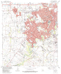 1983 Lafayette1983 Print · USGSLafayette and the surrounding Acadiana prairies underwent significant expansion in the early eighties as the energy industry and university campus grew. Researchers can locate numerous local burial grounds like Simon Cem and historic school sites including James Sch and Judice Sch.
 - 1983 Map of Broussard
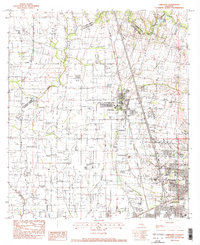
 1983 Broussard1983 Print · USGSLouisiana's Acadiana region comes into focus during the early 1980s as the urban growth of Lafayette pushes toward the historic rail towns. Genealogists and historians can trace families across the Southern Pacific line through Broussard, Pilette, and the Holy Rosary Institute.2 unique versions available
 - 1983 Map of Milton
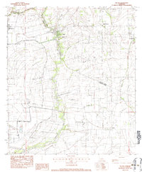 1983 Milton1983 Print · USGSThe Acadiana region in the early eighties shows a landscape of river-fronting settlements and extensive canal systems. Genealogists can locate family burial sites at Picard Cem and Bodoin Cem or trace the early bounds of Milton and Youngsville.2 unique versions available
 - 1983 Map of Carencro
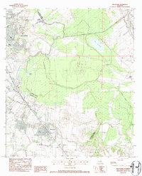
 1983 Carencro1983 Print · USGSThe Acadiana prairies north of Lafayette are shown here in the early eighties as oil exploration reshaped the rural landscape. Researchers can locate family landmarks in Carencro and Cankton, or trace the Southern Pacific line past Ossun Sch.2 unique versions available
 - 1984 Map of Baton Rouge
 1984 Baton Rouge1984 Print · USGSBaton Rouge and the surrounding river country are captured in the mid-eighties as the industrial corridor met the deep wetlands of the basin. Researchers can trace the winding Bayou Teche, locate family roots in St Martinville, or study the massive Atchafalaya Basin Floodway.2 unique versions available
 - 1985 Map of Crowley, 1986 Print
 1985 Crowley1986 Print · USGSCoastal prairie and bayou country are captured in the mid-eighties as the rice-and-rail economy defined South Louisiana life. Genealogists and researchers can trace family lands and rural hubs from Crowley to Jennings, following the paths of the Southern Pacific Railroad and the winding Mermentau River.2 unique versions available
End of results
Showing maps 1-6 of 6
Top cities near Lafayette
- New Iberia historical maps
- Abbeville historical maps
- Rayne historical maps
- Scott historical maps
- Breaux Bridge historical maps
- Carencro historical maps
See more
Top neighborhoods of Lafayette
- Mouton historical maps
- Arbolada Addition historical maps
- Elks historical maps
- Walroy historical maps
- Pilette historical maps
- Larabee historical maps
See more
Frequently asked questions
- What are the different types of historical maps available for Lafayette?
- What is the oldest map of Lafayette?
- Where can I purchase historical maps of Lafayette for my home or office?
- Where can I download high-res historical maps of Lafayette?
- Are there historical topographic maps available for Lafayette?
- Is there historical aerial imagery available for Lafayette?
- Where are historical maps of Lafayette sourced from?