1970s Maps of Lafayette, Louisiana
Explore 4 historic maps of Lafayette from the 1970s. These maps offer a rare glimpse into what life looked like during the 1970s — showing old roads, neighborhoods, homes, and landmarks that have changed or disappeared over time.
Whether you're researching your family's past, planning a metal detecting trip, or studying how Lafayette's landscape evolved across the 1970s, these high-resolution maps are a powerful tool for exploring the history of this region.
- Focus on a specific era: All maps on this page are from the 1970s, giving you a focused view of this time period.
- See what’s changed: Compare century-old streets, trails, and buildings to today's modern landscape using overlays and satellite layers.
- Research with precision: Use these maps for genealogy, historical research, land use analysis, or educational projects.
- View, download, or print: Maps are fully viewable online in high resolution, and can be downloaded or printed for your own records.
Start exploring Lafayette's history through authentic maps from the 1970s. This is your window into the past.
Lafayette, LA maps
(4)- 1970 Map of Carencro, 1972 Print
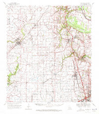 1970 Carencro1972 Print · USGSCajun country at the start of the seventies reveals a landscape where deep-rooted parish settlements like Grand Coteau exist alongside a booming energy industry. Trace family roots and local landmarks from Mt Pleasant Ch Cem to the Vatican Oil Field.
 - 1970 Map of St. Martinville, 1972 Print
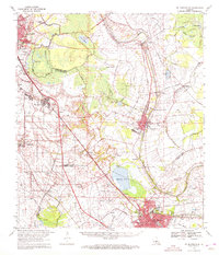 1970 St. Martinville1972 Print · USGSThe heart of Acadiana comes to life in the early 1970s as industrial growth meets the historic Bayou Teche. Genealogists and local historians can trace family-named sites and landmarks like Holy Name Institute, the Keystone Lock and Dam, and the old community at Duchamp.2 unique versions available
 - 1970 Map of Arnaudville, 1972 Print
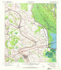 1970 Arnaudville1972 Print · USGSThe heart of Acadiana is captured here in the early seventies as Cajun communities grew along the winding Bayou Teche. Genealogists and historians can trace family roots through sites like Ridge Zion Cem, Leonville Sch, and the Missouri Pacific Railroad corridor.2 unique versions available
 - 1970 Map of Breaux Bridge, 1972 Print
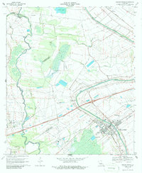 1970 Breaux Bridge1972 Print · USGSBreaux Bridge and the surrounding Cajun heartland are shown here in the early seventies, where water and industry shape the landscape. Genealogists and historians can trace family sites from Anse La Butte to Bushville or locate Strauss Cem and the Anse La Butte Oil and Gas Field.3 unique versions available
End of results
Showing maps 1-4 of 4
Top cities near Lafayette
- New Iberia historical maps
- Abbeville historical maps
- Rayne historical maps
- Scott historical maps
- Breaux Bridge historical maps
- Carencro historical maps
See more
Top neighborhoods of Lafayette
- Mouton historical maps
- Arbolada Addition historical maps
- Elks historical maps
- Walroy historical maps
- Pilette historical maps
- Larabee historical maps
See more
Frequently asked questions
- What are the different types of historical maps available for Lafayette?
- What is the oldest map of Lafayette?
- Where can I purchase historical maps of Lafayette for my home or office?
- Where can I download high-res historical maps of Lafayette?
- Are there historical topographic maps available for Lafayette?
- Is there historical aerial imagery available for Lafayette?
- Where are historical maps of Lafayette sourced from?