1950s Maps of Madison Parish, Louisiana
Explore 5 historic maps of Madison Parish from the 1950s. These maps offer a rare glimpse into what life looked like during the 1950s — showing old roads, neighborhoods, homes, and landmarks that have changed or disappeared over time.
Whether you're researching your family's past, planning a metal detecting trip, or studying how Madison Parish's landscape evolved across the 1950s, these high-resolution maps are a powerful tool for exploring the history of this region.
- Focus on a specific era: All maps on this page are from the 1950s, giving you a focused view of this time period.
- See what’s changed: Compare century-old streets, trails, and buildings to today's modern landscape using overlays and satellite layers.
- Research with precision: Use these maps for genealogy, historical research, land use analysis, or educational projects.
- View, download, or print: Maps are fully viewable online in high resolution, and can be downloaded or printed for your own records.
Start exploring Madison Parish's history through authentic maps from the 1950s. This is your window into the past.
Madison Parish, LA maps
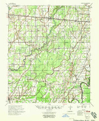
(5)- 1955 Map of Jackson
 1955 Jackson1955 Print · USGSThe Lower Mississippi Valley at the middle of the century reveals a landscape of deep river meanders and growing rail hubs. Genealogists and historians can trace the mid-century footprints of Vicksburg National Military Park, old river landings at Port Gibson, and the rail corridors of the Illinois Central Railroad.3 unique versions available
 - 1958 Map of Baskinton
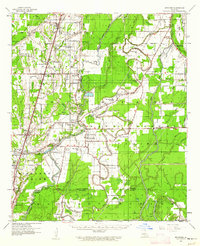
 1958 Baskinton1958 Print · USGSRichland and Franklin Parishes in the late fifties show a landscape transitioning between traditional bayou life and the post-war energy boom. Researchers can locate vanished rural landmarks like Hunters Chapel, the Delhi Refining Co, and old river stops like Indian Ldg.2 unique versions available
 - 1958 Map of Shackleford Lake
 1958 Shackleford Lake1958 Print · USGSTensas Parish was a landscape of timber and river landings in the mid-1950s, where the logging industry and the river's flow dictated local life. Genealogists and historians can trace the foundations of communities at Marydale Plantation, Magnolia Sch & Ch, and ancient sites like the Indian Mounds.
 - 1958 Map of Winnsboro
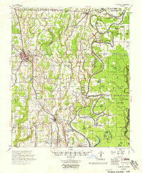 1958 Winnsboro1958 Print · USGSThe fertile landscape of Franklin Parish comes to life in the late 1950s, showing a region defined by the Missouri Pacific Railroad and the winding Macon Bayou. Genealogists and local historians can trace family locations near landmarks like True Light Cem & Ch, the Franklin Parish Training Sch, and Lorelein.
 - 1959 Map of Mitchiner, 1962 Print
 1959 Mitchiner1962 Print · USGSNortheastern Louisiana at the end of the fifties reveals a landscape of ancient earthworks and rising energy production. Genealogists can trace family roots through Bethany Cem & Ch, Adams Sch, and the historical significance of Poverty Pt.2 unique versions available
End of results
Showing maps 1-5 of 5
Top cities of Madison Parish
Frequently asked questions
- What are the different types of historical maps available for Madison Parish?
- What is the oldest map of Madison Parish?
- Where can I purchase historical maps of Madison Parish for my home or office?
- Where can I download high-res historical maps of Madison Parish?
- Are there historical topographic maps available for Madison Parish?
- Is there historical aerial imagery available for Madison Parish?
- Where are historical maps of Madison Parish sourced from?