1980s Maps of Madison Parish, Louisiana
Explore 15 historic maps of Madison Parish from the 1980s. These maps offer a rare glimpse into what life looked like during the 1980s — showing old roads, neighborhoods, homes, and landmarks that have changed or disappeared over time.
Whether you're researching your family's past, planning a metal detecting trip, or studying how Madison Parish's landscape evolved across the 1980s, these high-resolution maps are a powerful tool for exploring the history of this region.
- Focus on a specific era: All maps on this page are from the 1980s, giving you a focused view of this time period.
- See what’s changed: Compare century-old streets, trails, and buildings to today's modern landscape using overlays and satellite layers.
- Research with precision: Use these maps for genealogy, historical research, land use analysis, or educational projects.
- View, download, or print: Maps are fully viewable online in high resolution, and can be downloaded or printed for your own records.
Start exploring Madison Parish's history through authentic maps from the 1980s. This is your window into the past.
Madison Parish, LA maps
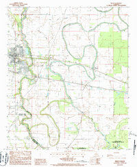
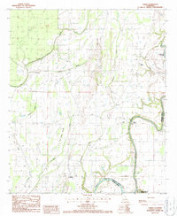
(15)- 1982 Map of Tallulah, 1983 Print
 1982 Tallulah1983 Print · USGSNortheast Louisiana in the early eighties was a landscape of intricate oxbow lakes and railroad towns. Researchers can trace the heritage of parish centers like Tallulah and Winnsboro, or locate rural landmarks near Yucatan Lake and the Illinois Central Gulf tracks.
 - 1982 Map of Bastrop, 1983 Print
 1982 Bastrop1983 Print · USGSNortheastern Louisiana and the Mississippi River Delta are captured here in the early eighties as a landscape of bayous and river towns. Genealogists and historians can trace small communities like Mer Rouge and Oak Grove or the ancient terrain of Poverty Point State Park.
 - 1983 Map of Crowville, 1984 Print
 1983 Crowville1984 Print · USGSFranklin Parish in the early eighties shows a landscape shaped by the winding Bayou Macon and a network of rural settlements. Genealogists can trace family landmarks like the Masonic Cem, Swampers (Killians Ferry), and numerous local congregations including Magnolia Ch.2 unique versions available
 - 1984 Map of Yazoo City
 1984 Yazoo City1984 Print · USGSThe Mississippi Delta and loess bluffs meet in the mid-eighties as the Yazoo River snakes through a dense network of wildlife areas and rail lines. Researchers can trace rural life and drainage history through small communities like Holly Bluff, Mechanicsburg, and Satartia.2 unique versions available
 - 1984 Map of Jackson
 1984 Jackson1984 Print · USGSCentral Mississippi in the mid-eighties shows a landscape defined by the growing suburbs of Jackson and the riverfront legacy of Vicksburg. Researchers can trace the Natchez Trace Parkway or locate local landmarks like Utica College and Mississippi State Hospital.
 - 1986 Map of Delhi, 1987 Print
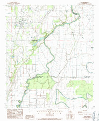
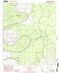
 1986 Delhi1987 Print · USGSRichland Parish in the mid-eighties was a landscape of deep bayous and active energy production. Genealogists and historians can trace the Illinois Central Gulf Railroad through Delhi, locate rural landmarks like Couch Lodge, and see the extent of the local Oil and Gas Field.
 - 1986 Map of Tendal, 1987 Print
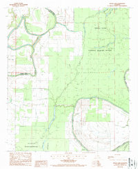
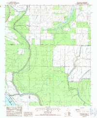
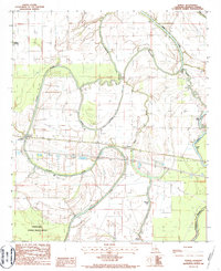 1986 Tendal1987 Print · USGSMadison Parish in the mid-1980s reveals a landscape shaped by the shifting currents of the Tensas River and the heavy timber of the bottomlands. Genealogists and researchers can trace the rail-side community of Tendal, the riverside village of Quebec, and numerous family-named waterways like Joes Bayou.2 unique versions available
 - 1986 Map of Epps, 1987 Print
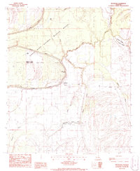
 1986 Epps1987 Print · USGSThe parish lines of northeast Louisiana converge here in the mid-1980s, documenting a landscape shaped by delta bayous and rural agriculture. Genealogists and local researchers can trace early roads and settlements from Epps to Mitchiner, alongside landmarks like Joes Bayou and several rural Cem locations.
 - 1987 Map of Westwood
 1987 Westwood1987 Print · USGSThe Louisiana Delta bottomlands are shown in detail during the late twentieth century, centered on the Tensas River. Genealogists and historians can trace the rural settlements of Westwood and Dearborn or locate Indian Mounds and a local Cem.
 - 1987 Map of Lamar
 1987 Lamar1987 Print · USGSIn the late 1980s, the Bayou Macon bottomlands formed a patchwork of agriculture and winding waterways. Local historians can trace old parish crossings at Warsaw Ferry and locate rural hubs like Lamar, Longview, and the remote Bakers.
 - 1987 Map of Indian Lake
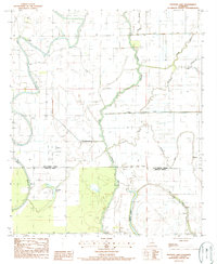
 1987 Indian Lake1987 Print · USGSMadison and Franklin Parishes in the late 1980s are defined by a complex web of wetlands and wildlife preserves. Researchers can trace the meandering Tensas River through the Tensas National Wildlife Refuge or locate the remote Landing Strip near Bakers Brake.
 - 1987 Map of Waverly SE
 1987 Waverly SE1987 Print · USGSMadison Parish’s bottomland wilderness is preserved here in the late eighties, showing a landscape dominated by the winding Tensas River. Researchers can trace the intricate network of oxbows and swampy terrain through named features like Horseshoe Lake, Rainey Brake, and Alligator Bayou.2 unique versions available
 - 1987 Map of Panther Lake
 1987 Panther Lake1987 Print · USGSThe Louisiana delta landscape comes alive in the late 1980s, where the winding courses of Tensas Bayou and Joes Bayou define the parish lines. Genealogists and historians can trace family-named landmarks like Fishers Creek or locate a quiet rural Cem near the water's edge.
 - 1987 Map of Tensas Bluff
 1987 Tensas Bluff1987 Print · USGSThe Tensas River bottomlands in the late 1980s show a landscape of conservation and river-driven geography. Trace the Old RR Grade and discover family-named landmarks like Trusler Lake and the distinctive Tensas Bluff.
 - 1988 Map of Cane Bayou
 1988 Cane Bayou1988 Print · USGSIssaquena and Warren counties are captured in the late 1980s as a complex network of bayous and oxbow lakes. Genealogists and historians can trace property lines against the Old Indian Treaty Bdy and the banks of Eagle Lake or Cypress Lake.
End of results
Showing maps 1-15 of 15
Top cities of Madison Parish
Frequently asked questions
- What are the different types of historical maps available for Madison Parish?
- What is the oldest map of Madison Parish?
- Where can I purchase historical maps of Madison Parish for my home or office?
- Where can I download high-res historical maps of Madison Parish?
- Are there historical topographic maps available for Madison Parish?
- Is there historical aerial imagery available for Madison Parish?
- Where are historical maps of Madison Parish sourced from?