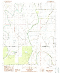
1987 Map of Panther Lake
USGS Topo · Published 1987About this map
Tensas Bayou and Joes Bayou snake through this alluvial landscape along the border of East Carroll Parish and Madison Parish. The terrain is defined by a dense network of meandering waterways, including Graveyard Bayou, Maiden Bayou, and Doe Bayou, illustrating the complex drainage patterns of the Mississippi Delta region in the late 1980s. A small Cem stands as a quiet marker of local history near the northern bends of Joes Bayou. Southward, Panther Lake and the northern reaches of Bear Lake provide prominent landmarks within this rural expanse. The lack of concentrated settlements highlights an area primarily shaped by its hydrology and the agricultural or wilderness utility of the Louisiana wetlands. Researchers can trace the intricate connections of smaller streams like Fishers Creek and Bull Bayou as they feed into the larger bayou systems.
Find a feature on this map
14 named features on this map. Tap any name to fly to it.
Don’t see what you’re looking for? This feature index may not catch every label — zoom into the map to look around manually.
Map Details
Editions of this 1987 Panther Lake Map
This is the sole edition of this map. No revisions or reprints were ever made.
Other maps of this area

1909 · Tallulah
USGS Topo · 1:24,000

1935 · Waverly
USGS Topo · 1:62,500

1939 · Talla Bena
USGS Topo · 1:62,500

1939 · Alsatia
USGS Topo · 1:62,500

1955 · Jackson
USGS Topo · 1:250,000

1959 · Mitchiner
USGS Topo · 1:62,500

1961 · Jackson
USGS Topo · 1:250,000

1961 · Waverly
USGS Topo · 1:62,500

1962 · Jackson
USGS Topo · 1:250,000
1963 · Tallulah
USGS Topo · 1:24,000