1950s Maps of Bastrop, Louisiana
Explore 3 historic maps of Bastrop from the 1950s. These maps offer a rare glimpse into what life looked like during the 1950s — showing old roads, neighborhoods, homes, and landmarks that have changed or disappeared over time.
Whether you're researching your family's past, planning a metal detecting trip, or studying how Bastrop's landscape evolved across the 1950s, these high-resolution maps are a powerful tool for exploring the history of this region.
- Focus on a specific era: All maps on this page are from the 1950s, giving you a focused view of this time period.
- See what’s changed: Compare century-old streets, trails, and buildings to today's modern landscape using overlays and satellite layers.
- Research with precision: Use these maps for genealogy, historical research, land use analysis, or educational projects.
- View, download, or print: Maps are fully viewable online in high resolution, and can be downloaded or printed for your own records.
Start exploring Bastrop's history through authentic maps from the 1950s. This is your window into the past.
Bastrop, LA maps
(3)- 1955 Map of Jackson
 1955 Jackson1955 Print · USGSThe Lower Mississippi Valley at the middle of the century reveals a landscape of deep river meanders and growing rail hubs. Genealogists and historians can trace the mid-century footprints of Vicksburg National Military Park, old river landings at Port Gibson, and the rail corridors of the Illinois Central Railroad.3 unique versions available
 - 1956 Map of Bastrop, 1957 Print
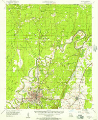 1956 Bastrop1957 Print · USGSMorehouse Parish in the mid-1950s is a landscape of thriving rail hubs and productive wetlands at the edge of the Arkansas border. Genealogists and historians can trace family roots through landmarks like Cherry Ridge Sch, Mer Rouge, and the Gas and Oil Field near Beekman.4 unique versions available
 - 1957 Map of Collinston, 1958 Print
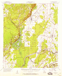 1957 Collinston1958 Print · USGSMorehouse and Richland Parishes are shown in the late fifties, featuring the transition from agricultural bayous to active gas fields. Genealogists can locate family landmarks like Cedar Grove Sch, William Chapel, and the ancient Indian Mounds near Oak Ridge.3 unique versions available
End of results
Showing maps 1-3 of 3
Top cities near Bastrop
- Monroe historical maps
- West Monroe historical maps
- Swartz historical maps
- Sterlington historical maps
- Mer Rouge historical maps
- Bonita historical maps
See more
Frequently asked questions
- What are the different types of historical maps available for Bastrop?
- What is the oldest map of Bastrop?
- Where can I purchase historical maps of Bastrop for my home or office?
- Where can I download high-res historical maps of Bastrop?
- Are there historical topographic maps available for Bastrop?
- Is there historical aerial imagery available for Bastrop?
- Where are historical maps of Bastrop sourced from?