Old Maps of Morehouse Parish, Louisiana
Explore 199 old maps of Morehouse Parish, spanning from 1934 to today. These high-resolution historic maps reveal how streets, neighborhoods, landmarks, and natural features evolved over time — perfect for genealogy, metal detecting, research, and local history exploration.
What you can do with these maps:
- See how Morehouse Parish changed over time: Compare historical maps to modern-day views to trace roads, homesites, rail lines & more.
- View detailed metadata: Each map includes creators, publishers, year, scale, and archive source.
- Overlay maps with satellite & LiDAR: Visualize the past alongside modern tools to explore terrain & human change.
- Trusted historical sources: Maps sourced from the USGS, Library of Congress, and other archives.
- Access maps your way: View online, download high-res files, or order prints for personal or research use.
Start exploring old maps of Morehouse Parish to uncover forgotten places, hidden landmarks, and the deep history beneath your feet.
Morehouse Parish, LA maps
(199)- 1934 Map of Felsenthal, 1954 Print
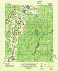
 1934 Felsenthal1954 Print · USGSThe Ouachita and Saline River basins are captured here in the early 1930s as logging and rail shaped the Arkansas-Louisiana border. Trace the industrial footprint of the Logging RR and Missouri Pacific RR alongside local centers like Felsenthal, Huttig, and Smith Chapel.2 unique versions available
 - 1935 Map of Collinston
 1935 Collinston1935 Print · USGSMorehouse and Ouachita Parishes are seen here in the mid-1930s during a period of heavy industrialization fueled by the natural gas boom. Researchers can trace the sprawling footprints of the Southern Carbon Co and find rural landmarks like Jerusalem Ch and the Indian Mounds.
 - 1935 Map of Wilmot, 1936 Print
 1935 Wilmot1936 Print · USGSSoutheast Arkansas in the mid-1930s shows a landscape defined by the winding Bayou Bartholomew and the growth of river-and-rail towns. Trace the river economy through Ohio Ldg, visit the Bethel Ch, or locate old school sites like Farmer Sch.3 unique versions available
 - 1935 Map of Naff, 1936 Print
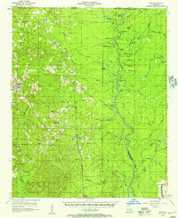
 1935 Naff1936 Print · USGSMorehouse Parish in the mid-1930s is a landscape of winding bayous and emerging industrial infrastructure. Genealogists and local historians can trace family locations near Bastrop, Shelton, and rural landmarks like Evergreen Ch and Cem or Pt Pleasant.
 - 1935 Map of Hurricane, 1936 Print
 1935 Hurricane1936 Print · USGSRichland and Morehouse Parishes are depicted in the mid-1930s as a complex network of bayous and river islands. Genealogists can trace rural life through landmarks like Point Jefferson, Antioch Ch, and several local schools including Prospect Sch.
 - 1935 Map of Oak Grove, 1938 Print
 1935 Oak Grove1938 Print · USGSNortheastern Louisiana in the mid-1930s is mapped here at the height of its rail and timber era. Researchers can trace the El Bruce Co Logging Tramway, find the Hill Sch, and locate family sites near Oak Grove and Forest.
 - 1935 Map of Bonita, 1943 Print
 1935 Bonita1943 Print · USGSLouisiana's delta country is captured here during the mid-1930s, showing a landscape defined by meandering bayous and small farming settlements. Genealogists can locate family landmarks like Mound Chapel Ch, the Johnson Sch, and the riverside Loverett Ferry.2 unique versions available
 - 1935 Map of Drew, 1947 Print
 1935 Drew1947 Print · USGSNorthern Louisiana's river country was defined by winding waterways and emerging energy infrastructure in the 1930s. Genealogists can trace early crossings like Whites Ferry and family-named locales such as Guthrie or the Childrens Home in Monroe.
 - 1935 Map of Haile, 1948 Print
 1935 Haile1948 Print · USGSThe Louisiana bayous and timberlands near the Ouachita River are captured here in the mid-1930s as the regional energy economy began to expand. Genealogists can locate family landmarks like St Pauls Church and the settlement of Marion, or trace industrial roots through the Abandoned Logging Railroad and river landings.
 - 1936 Map of Eudora, 1943 Print
 1936 Eudora1943 Print · USGSSoutheast Arkansas and northeast Louisiana are captured here in the mid-1930s, showing a landscape shaped by water management and rail transport. Researchers can trace the early energy infrastructure of the Standard Oil Pipe Line or locate rural landmarks like Holly Ridge Ch and Empire.
 - 1937 Map of Felsenthal
 1937 Felsenthal1937 Print · USGSThe Ouachita River bottomlands come to life in the mid-1930s, showing a landscape of logging railroads and river bends. Trace family roots through Lapile Cem, Huttig, and Felsenthal, or locate vanished landmarks like Cooter Sch and Dollar Junction.
 - 1938 Map of Felsenthal
 1938 Felsenthal1938 Print · USGSThe river bottoms of south Arkansas and north Louisiana are seen here in the late 1930s, showing a landscape defined by the winding Ouachita River. Genealogists and historians can locate the old townsite of Felsenthal, rural landmarks like Smiths Chapel, and the river landing at Prairie Island Ldg.
 - 1939 Map of Felsenthal
 1939 Felsenthal1939 Print · USGSThe river bottomlands of southern Arkansas and northern Louisiana come alive in the late thirties as the timber industry reshapes the landscape. Researchers can trace the sprawling rail lines of the Missouri Pacific, the industrial layout of Huttig, and rural sites like Smith Chapel or the Macedonian Cem.2 unique versions available
 - 1953 Map of Greenwood, 1966 Print
 1953 Greenwood1966 Print · USGSThe Mississippi Delta in the mid-fifties is captured here as a thriving network of river towns, railroads, and oxbow lakes. Researchers can trace the legacy of the Illinois Central Railroad and locate landmarks like the State Penal Farm and Greenville Air Force Base.5 unique versions available
 - 1953 Map of El Dorado, 1967 Print
 1953 El Dorado1967 Print · USGSSouth Arkansas in the mid-1960s was a landscape of industrial growth and river-fed commerce. Researchers can trace the extensive Oil and Gas Fields around Magnolia, the expansive U S Naval Ammunition Depot, and the busy rail lines of the Missouri Pacific.3 unique versions available
 - 1955 Map of Jackson
 1955 Jackson1955 Print · USGSThe Lower Mississippi Valley at the middle of the century reveals a landscape of deep river meanders and growing rail hubs. Genealogists and historians can trace the mid-century footprints of Vicksburg National Military Park, old river landings at Port Gibson, and the rail corridors of the Illinois Central Railroad.3 unique versions available
 - 1955 Map of Shreveport
 1955 Shreveport1955 Print · USGSNorthern Louisiana in the mid-fifties is captured here as a landscape of military bases, vast oil fields, and burgeoning college towns. Genealogists and historians can trace the rail-and-river economy through the Monroe Gas Field, Grambling College, and Barksdale Air Force Base.3 unique versions available
 - 1956 Map of Shreveport
 1956 Shreveport1956 Print · USGSNorthern Louisiana during the mid-fifties presents a complex landscape of booming oil fields and strategic military installations. Genealogists and historians can trace the infrastructure of the Monroe Gas Field and family-named locales from Cotton Valley to Jonesboro.
 - 1956 Map of Greenwood
 1956 Greenwood1956 Print · USGSThe Mississippi Delta in the mid-fifties is captured here during a period of significant military and agricultural activity. Researchers can trace the rail lines of the Illinois Central RR, find the Greenville Air Force Base, or locate the State Penal Farm.
 - 1956 Map of Bastrop, 1957 Print
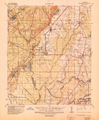
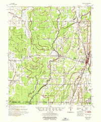
 1956 Bastrop1957 Print · USGSMorehouse Parish in the mid-1950s is a landscape of thriving rail hubs and productive wetlands at the edge of the Arkansas border. Genealogists and historians can trace family roots through landmarks like Cherry Ridge Sch, Mer Rouge, and the Gas and Oil Field near Beekman.4 unique versions available
 - 1956 Map of Haile, 1957 Print
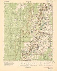
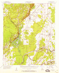
 1956 Haile1957 Print · USGSUnion Parish and the bottomlands of the Quachita River are shown here in the mid-1950s as a landscape of timber, rail, and river landings. Researchers can trace family history through sites like Hollman Sch, St Johns Ch, and the Missouri Pacific line through Haile.4 unique versions available
 - 1957 Map of El Dorado
 1957 El Dorado1957 Print · USGSSouth Arkansas in the mid-1950s was a critical hub of military logistics and rail-river commerce. Genealogists and historians can trace family land across the Arkansas Louisiana border and locate sites like the U.S. Naval Ammunition Depot or the rail junctions at Magnolia and Camden.
 - 1957 Map of Eudora
 1957 Eudora1957 Print · USGSSoutheast Arkansas and Northeast Louisiana are captured here in the late 1950s, showing a delta landscape defined by winding bayous and rural community life. Researchers can trace family roots through numerous local landmarks like Masons Cem, Ross Van Ness Sch, and Holly Sch.2 unique versions available
 - 1957 Map of Monroe North, 1958 Print
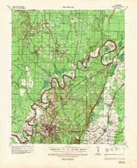
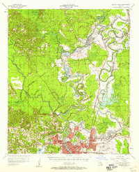 1957 Monroe North1958 Print · USGSNorth of the city center in the late fifties, the riverfront and bayous define a landscape of growing neighborhoods and industrial sites. Researchers can trace family roots through landmarks like Bean Chapel, Neville High Sch, and the grounds of Selman Airport.2 unique versions available
 - 1957 Map of Collinston, 1958 Print
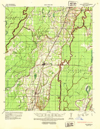
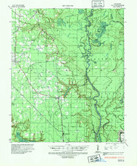
 1957 Collinston1958 Print · USGSMorehouse and Richland Parishes are shown in the late fifties, featuring the transition from agricultural bayous to active gas fields. Genealogists can locate family landmarks like Cedar Grove Sch, William Chapel, and the ancient Indian Mounds near Oak Ridge.3 unique versions available
Showing maps 1-25 of 199
Top cities of Morehouse Parish
- Bastrop historical maps
- Mer Rouge historical maps
- Bonita historical maps
- Collinston historical maps
- Oak Ridge historical maps
Frequently asked questions
- What are the different types of historical maps available for Morehouse Parish?
- What is the oldest map of Morehouse Parish?
- Where can I purchase historical maps of Morehouse Parish for my home or office?
- Where can I download high-res historical maps of Morehouse Parish?
- Are there historical topographic maps available for Morehouse Parish?
- Is there historical aerial imagery available for Morehouse Parish?
- Where are historical maps of Morehouse Parish sourced from?